You are here: Home > Network List > UW - Pacific Northwest Regional Seismic Network Stations List
> Station RCM Mt. Rainier, Camp Muir > Earthquake Result Viewer
RCM Mt. Rainier, Camp Muir - Earthquake Result Viewer
| Earthquake location: |
Tonga Islands |
| Earthquake latitude/longitude: |
-19.1/-173.6 |
| Earthquake time(UTC): |
2020/10/01 (275) 01:13:39 GMT |
| Earthquake Depth: |
10 km |
| Earthquake Magnitude: |
6.7 Mi |
| Earthquake Catalog/Contributor: |
NEIC PDE/at |
|
| Network: |
UW Pacific Northwest Regional Seismic Network |
| Station: |
RCM Mt. Rainier, Camp Muir |
| Lat/Lon: |
46.84 N/121.73 W |
| Elevation: |
3085 m |
|
| Distance: |
80.5 deg |
| Az: |
33.193 deg |
| Baz: |
228.944 deg |
| Ray Param: |
0.04820779 |
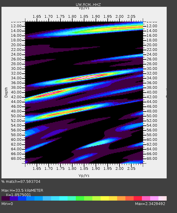
| Estimated Moho Depth: |
33.5 km |
| Estimated Crust Vp/Vs: |
1.86 |
| Assumed Crust Vp: |
6.597 km/s |
| Estimated Crust Vs: |
3.552 km/s |
| Estimated Crust Poisson's Ratio: |
0.30 |
|
| Radial Match: |
87.593704 % |
| Radial Bump: |
400 |
| Transverse Match: |
82.09186 % |
| Transverse Bump: |
400 |
| SOD ConfigId: |
22732711 |
| Insert Time: |
2020-10-15 01:47:24.323 +0000 |
| GWidth: |
2.5 |
| Max Bumps: |
400 |
| Tol: |
0.001 |
|

Signal To Noise
| Channel | StoN | STA | LTA |
| UW:RCM: :HHZ:20201001T01:25:19.909973Z | 18.743702 | 2.9246826E-6 | 1.5603548E-7 |
| UW:RCM: :HHN:20201001T01:25:19.909973Z | 7.846843 | 2.0634645E-6 | 2.6296746E-7 |
| UW:RCM: :HHE:20201001T01:25:19.909973Z | 8.723802 | 1.6419472E-6 | 1.8821464E-7 |
| Arrivals |
| Ps | 4.5 SECOND |
| PpPs | 14 SECOND |
| PsPs/PpSs | 19 SECOND |


