You are here: Home > Network List > AG - Arkansas Seismic Network Stations List
> Station WHAR Woolly Hollow State Park,AR > Earthquake Result Viewer
WHAR Woolly Hollow State Park,AR - Earthquake Result Viewer
| Earthquake location: |
Tonga Islands |
| Earthquake latitude/longitude: |
-19.5/-174.2 |
| Earthquake time(UTC): |
2020/10/01 (275) 01:13:37 GMT |
| Earthquake Depth: |
35 km |
| Earthquake Magnitude: |
6.4 Mww |
| Earthquake Catalog/Contributor: |
NEIC PDE/us |
|
| Network: |
AG Arkansas Seismic Network |
| Station: |
WHAR Woolly Hollow State Park,AR |
| Lat/Lon: |
35.29 N/92.29 W |
| Elevation: |
184 m |
|
| Distance: |
94.7 deg |
| Az: |
54.365 deg |
| Baz: |
249.594 deg |
| Ray Param: |
0.040958185 |
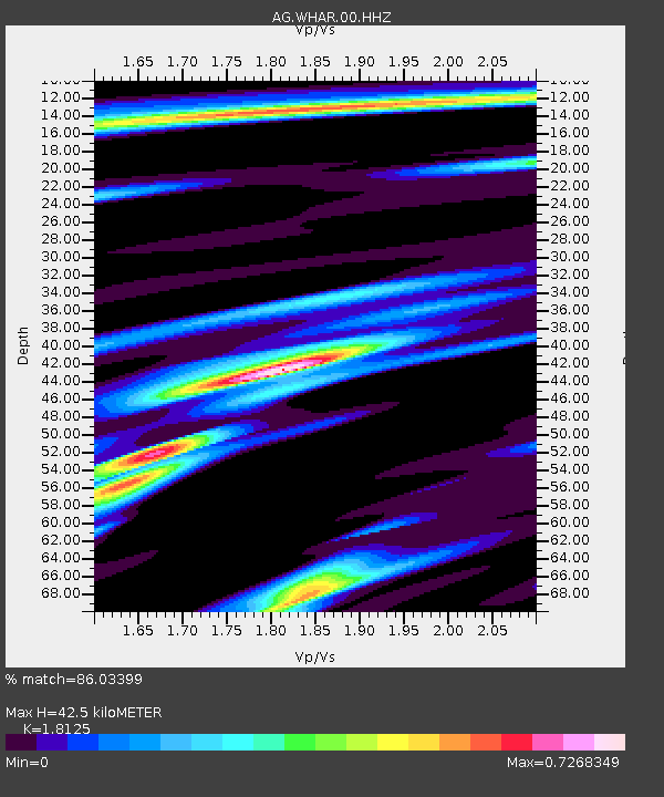
| Estimated Moho Depth: |
42.5 km |
| Estimated Crust Vp/Vs: |
1.81 |
| Assumed Crust Vp: |
6.498 km/s |
| Estimated Crust Vs: |
3.585 km/s |
| Estimated Crust Poisson's Ratio: |
0.28 |
|
| Radial Match: |
86.03399 % |
| Radial Bump: |
341 |
| Transverse Match: |
76.257576 % |
| Transverse Bump: |
375 |
| SOD ConfigId: |
22732711 |
| Insert Time: |
2020-10-15 01:49:31.416 +0000 |
| GWidth: |
2.5 |
| Max Bumps: |
400 |
| Tol: |
0.001 |
|

Signal To Noise
| Channel | StoN | STA | LTA |
| AG:WHAR:00:HHZ:20201001T01:26:24.149977Z | 13.622164 | 1.8663162E-6 | 1.3700586E-7 |
| AG:WHAR:00:HHN:20201001T01:26:24.149977Z | 0.96849954 | 1.774495E-7 | 1.8322103E-7 |
| AG:WHAR:00:HHE:20201001T01:26:24.149977Z | 3.8144114 | 4.939126E-7 | 1.2948591E-7 |
| Arrivals |
| Ps | 5.4 SECOND |
| PpPs | 18 SECOND |
| PsPs/PpSs | 23 SECOND |


