You are here: Home > Network List > AK - Alaska Regional Network Stations List
> Station BARN Barnard Glacier, AK, USA > Earthquake Result Viewer
BARN Barnard Glacier, AK, USA - Earthquake Result Viewer
| Earthquake location: |
Tonga Islands |
| Earthquake latitude/longitude: |
-19.5/-174.2 |
| Earthquake time(UTC): |
2020/10/01 (275) 01:13:37 GMT |
| Earthquake Depth: |
35 km |
| Earthquake Magnitude: |
6.4 Mww |
| Earthquake Catalog/Contributor: |
NEIC PDE/us |
|
| Network: |
AK Alaska Regional Network |
| Station: |
BARN Barnard Glacier, AK, USA |
| Lat/Lon: |
61.06 N/141.66 W |
| Elevation: |
1689 m |
|
| Distance: |
84.4 deg |
| Az: |
15.25 deg |
| Baz: |
210.674 deg |
| Ray Param: |
0.045437172 |
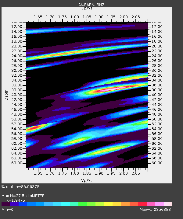
| Estimated Moho Depth: |
37.5 km |
| Estimated Crust Vp/Vs: |
1.95 |
| Assumed Crust Vp: |
6.566 km/s |
| Estimated Crust Vs: |
3.372 km/s |
| Estimated Crust Poisson's Ratio: |
0.32 |
|
| Radial Match: |
85.96378 % |
| Radial Bump: |
321 |
| Transverse Match: |
79.915 % |
| Transverse Bump: |
400 |
| SOD ConfigId: |
22732711 |
| Insert Time: |
2020-10-15 01:49:46.075 +0000 |
| GWidth: |
2.5 |
| Max Bumps: |
400 |
| Tol: |
0.001 |
|

Signal To Noise
| Channel | StoN | STA | LTA |
| AK:BARN: :BHZ:20201001T01:25:35.588026Z | 9.684125 | 2.7995893E-6 | 2.890906E-7 |
| AK:BARN: :BHN:20201001T01:25:35.588026Z | 3.7578442 | 1.0771992E-6 | 2.866535E-7 |
| AK:BARN: :BHE:20201001T01:25:35.588026Z | 2.3360276 | 5.9714375E-7 | 2.5562358E-7 |
| Arrivals |
| Ps | 5.5 SECOND |
| PpPs | 16 SECOND |
| PsPs/PpSs | 22 SECOND |


