You are here: Home > Network List > UU - University of Utah Regional Network Stations List
> Station TCU Toone Canyon, UT, USA > Earthquake Result Viewer
TCU Toone Canyon, UT, USA - Earthquake Result Viewer
| Earthquake location: |
Fiji Islands Region |
| Earthquake latitude/longitude: |
-18.0/-178.9 |
| Earthquake time(UTC): |
2017/08/19 (231) 02:00:52 GMT |
| Earthquake Depth: |
539 km |
| Earthquake Magnitude: |
6.4 Mww |
| Earthquake Catalog/Contributor: |
NEIC PDE/us |
|
| Network: |
UU University of Utah Regional Network |
| Station: |
TCU Toone Canyon, UT, USA |
| Lat/Lon: |
41.12 N/111.41 W |
| Elevation: |
2269 m |
|
| Distance: |
85.7 deg |
| Az: |
44.404 deg |
| Baz: |
241.825 deg |
| Ray Param: |
0.043060597 |
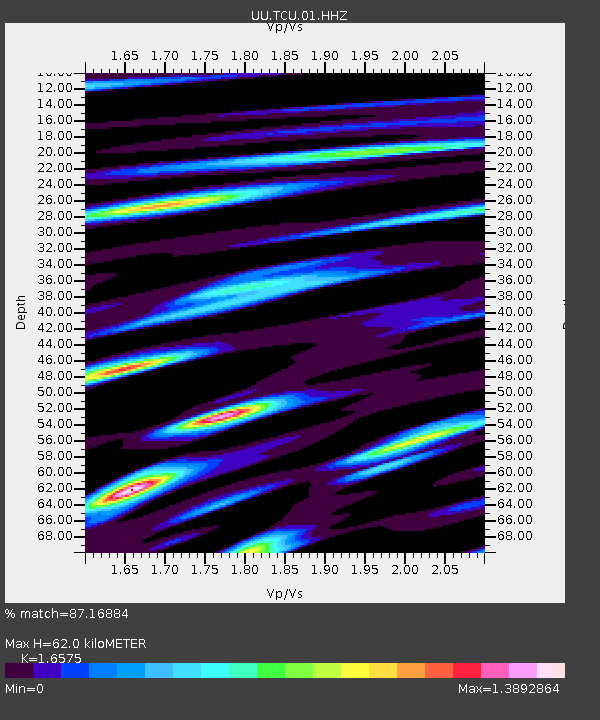
| Estimated Moho Depth: |
62.0 km |
| Estimated Crust Vp/Vs: |
1.66 |
| Assumed Crust Vp: |
6.155 km/s |
| Estimated Crust Vs: |
3.713 km/s |
| Estimated Crust Poisson's Ratio: |
0.21 |
|
| Radial Match: |
87.16884 % |
| Radial Bump: |
371 |
| Transverse Match: |
84.08665 % |
| Transverse Bump: |
325 |
| SOD ConfigId: |
2140511 |
| Insert Time: |
2017-09-01 18:02:05.215 +0000 |
| GWidth: |
2.5 |
| Max Bumps: |
400 |
| Tol: |
0.001 |
|

Signal To Noise
| Channel | StoN | STA | LTA |
| UU:TCU:01:HHZ:20170819T02:12:02.709983Z | 24.184856 | 7.643474E-8 | 3.1604381E-9 |
| UU:TCU:01:HHN:20170819T02:12:02.709983Z | 2.9346359 | 1.0699881E-8 | 3.6460677E-9 |
| UU:TCU:01:HHE:20170819T02:12:02.709983Z | 9.572665 | 3.1505177E-8 | 3.2911602E-9 |
| Arrivals |
| Ps | 6.8 SECOND |
| PpPs | 26 SECOND |
| PsPs/PpSs | 33 SECOND |


