You are here: Home > Network List > AV - Alaska Volcano Observatory Stations List
> Station PLBL Mt. Peulik Volcano, Alaska > Earthquake Result Viewer
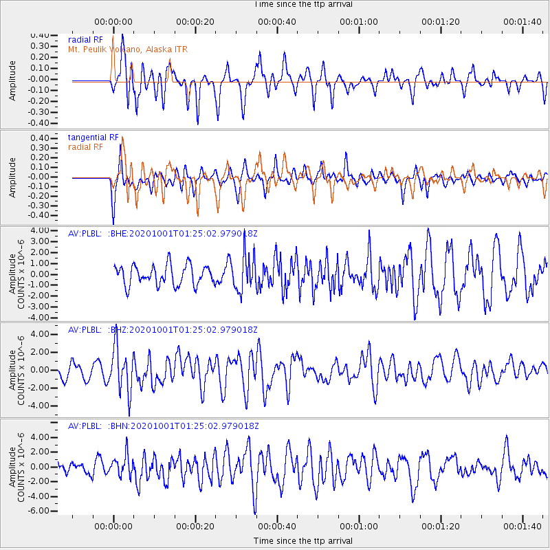
PLBL Mt. Peulik Volcano, Alaska - Earthquake Result Viewer
*The percent match for this event was below the threshold and hence no stack was calculated.
| Earthquake location: |
Tonga Islands |
| Earthquake latitude/longitude: |
-19.5/-174.2 |
| Earthquake time(UTC): |
2020/10/01 (275) 01:13:37 GMT |
| Earthquake Depth: |
35 km |
| Earthquake Magnitude: |
6.4 Mww |
| Earthquake Catalog/Contributor: |
NEIC PDE/us |
|
| Network: |
AV Alaska Volcano Observatory |
| Station: |
PLBL Mt. Peulik Volcano, Alaska |
| Lat/Lon: |
57.70 N/156.82 W |
| Elevation: |
461 m |
|
| Distance: |
78.3 deg |
| Az: |
9.441 deg |
| Baz: |
196.751 deg |
| Ray Param: |
$rayparam |
*The percent match for this event was below the threshold and hence was not used in the summary stack. |
|
| Radial Match: |
72.75382 % |
| Radial Bump: |
400 |
| Transverse Match: |
66.64221 % |
| Transverse Bump: |
400 |
| SOD ConfigId: |
22732711 |
| Insert Time: |
2020-10-15 01:55:45.482 +0000 |
| GWidth: |
2.5 |
| Max Bumps: |
400 |
| Tol: |
0.001 |
|
Signal To Noise
| Channel | StoN | STA | LTA |
| AV:PLBL: :BHZ:20201001T01:25:02.979018Z | 2.8741183 | 2.5105667E-6 | 8.7350844E-7 |
| AV:PLBL: :BHN:20201001T01:25:02.979018Z | 1.7385484 | 1.42007E-6 | 8.168136E-7 |
| AV:PLBL: :BHE:20201001T01:25:02.979018Z | 1.838677 | 1.6581379E-6 | 9.018103E-7 |
| Arrivals |
| Ps | |
| PpPs | |
| PsPs/PpSs | |


