You are here: Home > Network List > AZ - ANZA Regional Network Stations List
> Station RRSP RRSP, CA, USA > Earthquake Result Viewer
RRSP RRSP, CA, USA - Earthquake Result Viewer
| Earthquake location: |
Tonga Islands |
| Earthquake latitude/longitude: |
-19.5/-174.2 |
| Earthquake time(UTC): |
2020/10/01 (275) 01:13:37 GMT |
| Earthquake Depth: |
35 km |
| Earthquake Magnitude: |
6.4 Mww |
| Earthquake Catalog/Contributor: |
NEIC PDE/us |
|
| Network: |
AZ ANZA Regional Network |
| Station: |
RRSP RRSP, CA, USA |
| Lat/Lon: |
33.65 N/116.74 W |
| Elevation: |
1610 m |
|
| Distance: |
76.1 deg |
| Az: |
46.433 deg |
| Baz: |
235.03 deg |
| Ray Param: |
0.05116075 |
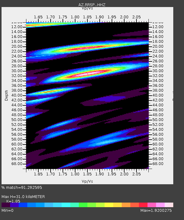
| Estimated Moho Depth: |
31.0 km |
| Estimated Crust Vp/Vs: |
1.85 |
| Assumed Crust Vp: |
6.264 km/s |
| Estimated Crust Vs: |
3.386 km/s |
| Estimated Crust Poisson's Ratio: |
0.29 |
|
| Radial Match: |
91.292595 % |
| Radial Bump: |
400 |
| Transverse Match: |
79.78439 % |
| Transverse Bump: |
394 |
| SOD ConfigId: |
22732711 |
| Insert Time: |
2020-10-15 01:56:38.823 +0000 |
| GWidth: |
2.5 |
| Max Bumps: |
400 |
| Tol: |
0.001 |
|

Signal To Noise
| Channel | StoN | STA | LTA |
| AZ:RRSP: :HHZ:20201001T01:24:50.969008Z | 13.614095 | 4.028113E-6 | 2.9587815E-7 |
| AZ:RRSP: :HHN:20201001T01:24:50.969008Z | 5.1667337 | 1.7322767E-6 | 3.3527502E-7 |
| AZ:RRSP: :HHE:20201001T01:24:50.969008Z | 3.121148 | 1.4254115E-6 | 4.566946E-7 |
| Arrivals |
| Ps | 4.3 SECOND |
| PpPs | 14 SECOND |
| PsPs/PpSs | 18 SECOND |


