You are here: Home > Network List > TX - Texas Seismological Network Stations List
> Station ALPN Alpine > Earthquake Result Viewer
ALPN Alpine - Earthquake Result Viewer
| Earthquake location: |
Fiji Islands Region |
| Earthquake latitude/longitude: |
-18.0/-178.9 |
| Earthquake time(UTC): |
2017/08/19 (231) 02:00:52 GMT |
| Earthquake Depth: |
539 km |
| Earthquake Magnitude: |
6.4 Mww |
| Earthquake Catalog/Contributor: |
NEIC PDE/us |
|
| Network: |
TX Texas Seismological Network |
| Station: |
ALPN Alpine |
| Lat/Lon: |
30.37 N/103.64 W |
| Elevation: |
1368 m |
|
| Distance: |
86.8 deg |
| Az: |
56.813 deg |
| Baz: |
247.183 deg |
| Ray Param: |
0.04226854 |
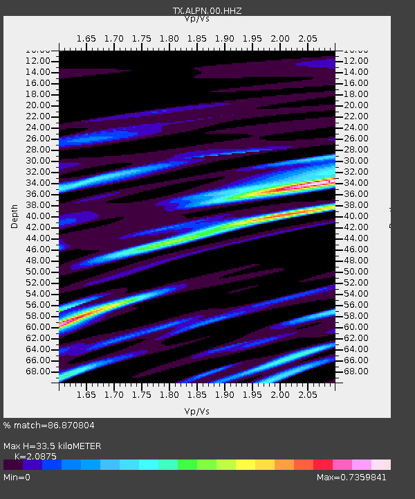
| Estimated Moho Depth: |
33.5 km |
| Estimated Crust Vp/Vs: |
2.09 |
| Assumed Crust Vp: |
6.121 km/s |
| Estimated Crust Vs: |
2.932 km/s |
| Estimated Crust Poisson's Ratio: |
0.35 |
|
| Radial Match: |
86.870804 % |
| Radial Bump: |
380 |
| Transverse Match: |
69.504524 % |
| Transverse Bump: |
400 |
| SOD ConfigId: |
2140511 |
| Insert Time: |
2017-09-01 18:03:29.155 +0000 |
| GWidth: |
2.5 |
| Max Bumps: |
400 |
| Tol: |
0.001 |
|

Signal To Noise
| Channel | StoN | STA | LTA |
| TX:ALPN:00:HHZ:20170819T02:12:07.959983Z | 27.318094 | 1.4197944E-6 | 5.1972677E-8 |
| TX:ALPN:00:HH1:20170819T02:12:07.959983Z | 8.841831 | 5.344764E-7 | 6.0448606E-8 |
| TX:ALPN:00:HH2:20170819T02:12:07.959983Z | 2.4192975 | 1.8188778E-7 | 7.5182065E-8 |
| Arrivals |
| Ps | 6.1 SECOND |
| PpPs | 17 SECOND |
| PsPs/PpSs | 23 SECOND |


