You are here: Home > Network List > CI - Caltech Regional Seismic Network Stations List
> Station VTV Victorville, California, USA > Earthquake Result Viewer
VTV Victorville, California, USA - Earthquake Result Viewer
| Earthquake location: |
Tonga Islands |
| Earthquake latitude/longitude: |
-19.5/-174.2 |
| Earthquake time(UTC): |
2020/10/01 (275) 01:13:37 GMT |
| Earthquake Depth: |
35 km |
| Earthquake Magnitude: |
6.4 Mww |
| Earthquake Catalog/Contributor: |
NEIC PDE/us |
|
| Network: |
CI Caltech Regional Seismic Network |
| Station: |
VTV Victorville, California, USA |
| Lat/Lon: |
34.56 N/117.33 W |
| Elevation: |
812 m |
|
| Distance: |
76.2 deg |
| Az: |
45.379 deg |
| Baz: |
234.449 deg |
| Ray Param: |
0.05108522 |
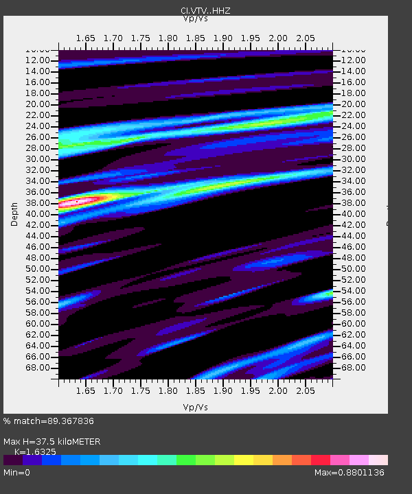
| Estimated Moho Depth: |
37.5 km |
| Estimated Crust Vp/Vs: |
1.63 |
| Assumed Crust Vp: |
6.276 km/s |
| Estimated Crust Vs: |
3.844 km/s |
| Estimated Crust Poisson's Ratio: |
0.20 |
|
| Radial Match: |
89.367836 % |
| Radial Bump: |
330 |
| Transverse Match: |
80.87814 % |
| Transverse Bump: |
383 |
| SOD ConfigId: |
22732711 |
| Insert Time: |
2020-10-15 02:01:26.885 +0000 |
| GWidth: |
2.5 |
| Max Bumps: |
400 |
| Tol: |
0.001 |
|

Signal To Noise
| Channel | StoN | STA | LTA |
| CI:VTV: :HHZ:20201001T01:24:51.667982Z | 14.972771 | 3.1545512E-6 | 2.1068587E-7 |
| CI:VTV: :HHN:20201001T01:24:51.667982Z | 2.284043 | 6.0096585E-7 | 2.6311494E-7 |
| CI:VTV: :HHE:20201001T01:24:51.667982Z | 4.070242 | 1.1557502E-6 | 2.8395124E-7 |
| Arrivals |
| Ps | 3.9 SECOND |
| PpPs | 15 SECOND |
| PsPs/PpSs | 19 SECOND |


