You are here: Home > Network List > GS - US Geological Survey Networks Stations List
> Station ASA3 ASA3 > Earthquake Result Viewer
ASA3 ASA3 - Earthquake Result Viewer
| Earthquake location: |
Tonga Islands |
| Earthquake latitude/longitude: |
-19.5/-174.2 |
| Earthquake time(UTC): |
2020/10/01 (275) 01:13:37 GMT |
| Earthquake Depth: |
35 km |
| Earthquake Magnitude: |
6.4 Mww |
| Earthquake Catalog/Contributor: |
NEIC PDE/us |
|
| Network: |
GS US Geological Survey Networks |
| Station: |
ASA3 ASA3 |
| Lat/Lon: |
34.95 N/106.46 W |
| Elevation: |
1819 m |
|
| Distance: |
84.0 deg |
| Az: |
49.868 deg |
| Baz: |
241.4 deg |
| Ray Param: |
0.045727346 |
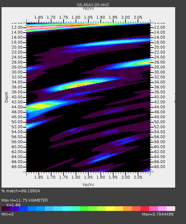
| Estimated Moho Depth: |
11.75 km |
| Estimated Crust Vp/Vs: |
1.66 |
| Assumed Crust Vp: |
6.502 km/s |
| Estimated Crust Vs: |
3.917 km/s |
| Estimated Crust Poisson's Ratio: |
0.22 |
|
| Radial Match: |
96.18904 % |
| Radial Bump: |
400 |
| Transverse Match: |
92.21647 % |
| Transverse Bump: |
400 |
| SOD ConfigId: |
22732711 |
| Insert Time: |
2020-10-15 02:03:57.140 +0000 |
| GWidth: |
2.5 |
| Max Bumps: |
400 |
| Tol: |
0.001 |
|

Signal To Noise
| Channel | StoN | STA | LTA |
| GS:ASA3:00:HHZ:20201001T01:25:33.479018Z | 53.34417 | 5.6330177E-6 | 1.0559763E-7 |
| GS:ASA3:00:HH1:20201001T01:25:33.479018Z | 6.8379426 | 9.254311E-7 | 1.3533766E-7 |
| GS:ASA3:00:HH2:20201001T01:25:33.479018Z | 20.192633 | 1.541429E-6 | 7.633621E-8 |
| Arrivals |
| Ps | 1.2 SECOND |
| PpPs | 4.7 SECOND |
| PsPs/PpSs | 5.9 SECOND |


