You are here: Home > Network List > XT97 - Colorado BB Array - Lodore Stations List
> Station JWM XT.JWM > Earthquake Result Viewer
JWM XT.JWM - Earthquake Result Viewer
| Earthquake location: |
Colombia |
| Earthquake latitude/longitude: |
3.8/-75.7 |
| Earthquake time(UTC): |
1997/09/02 (245) 12:13:22 GMT |
| Earthquake Depth: |
199 km |
| Earthquake Magnitude: |
6.5 MB, 6.8 UNKNOWN, 6.4 ME |
| Earthquake Catalog/Contributor: |
WHDF/NEIC |
|
| Network: |
XT Colorado BB Array - Lodore |
| Station: |
JWM XT.JWM |
| Lat/Lon: |
40.57 N/108.60 W |
| Elevation: |
2077 m |
|
| Distance: |
47.0 deg |
| Az: |
325.61 deg |
| Baz: |
132.282 deg |
| Ray Param: |
0.06951984 |
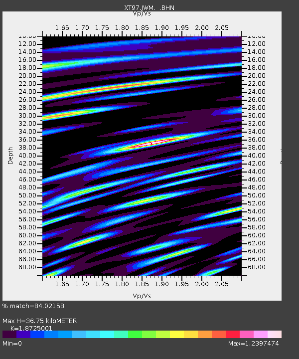
| Estimated Moho Depth: |
36.75 km |
| Estimated Crust Vp/Vs: |
1.87 |
| Assumed Crust Vp: |
6.207 km/s |
| Estimated Crust Vs: |
3.315 km/s |
| Estimated Crust Poisson's Ratio: |
0.30 |
|
| Radial Match: |
84.02158 % |
| Radial Bump: |
400 |
| Transverse Match: |
68.098495 % |
| Transverse Bump: |
400 |
| SOD ConfigId: |
6273 |
| Insert Time: |
2010-03-09 01:35:33.681 +0000 |
| GWidth: |
2.5 |
| Max Bumps: |
400 |
| Tol: |
0.001 |
|

Signal To Noise
| Channel | StoN | STA | LTA |
| XT:JWM: :BHN:19970902T12:21:03.625006Z | 17.841927 | 1.3549247E-6 | 7.59405E-8 |
| XT:JWM: :BHE:19970902T12:21:03.625006Z | 17.947212 | 1.6587128E-6 | 9.242175E-8 |
| XT:JWM: :BHZ:19970902T12:21:03.625006Z | 44.754284 | 3.7387738E-6 | 8.354002E-8 |
| Arrivals |
| Ps | 5.4 SECOND |
| PpPs | 16 SECOND |
| PsPs/PpSs | 22 SECOND |


