You are here: Home > Network List > N4 - Central and EAstern US Network Stations List
> Station TUL3 Leonard, OK, USA > Earthquake Result Viewer
TUL3 Leonard, OK, USA - Earthquake Result Viewer
| Earthquake location: |
Tonga Islands |
| Earthquake latitude/longitude: |
-19.5/-174.2 |
| Earthquake time(UTC): |
2020/10/01 (275) 01:13:37 GMT |
| Earthquake Depth: |
35 km |
| Earthquake Magnitude: |
6.4 Mww |
| Earthquake Catalog/Contributor: |
NEIC PDE/us |
|
| Network: |
N4 Central and EAstern US Network |
| Station: |
TUL3 Leonard, OK, USA |
| Lat/Lon: |
35.91 N/95.79 W |
| Elevation: |
265 m |
|
| Distance: |
92.3 deg |
| Az: |
52.746 deg |
| Baz: |
247.662 deg |
| Ray Param: |
0.04147116 |
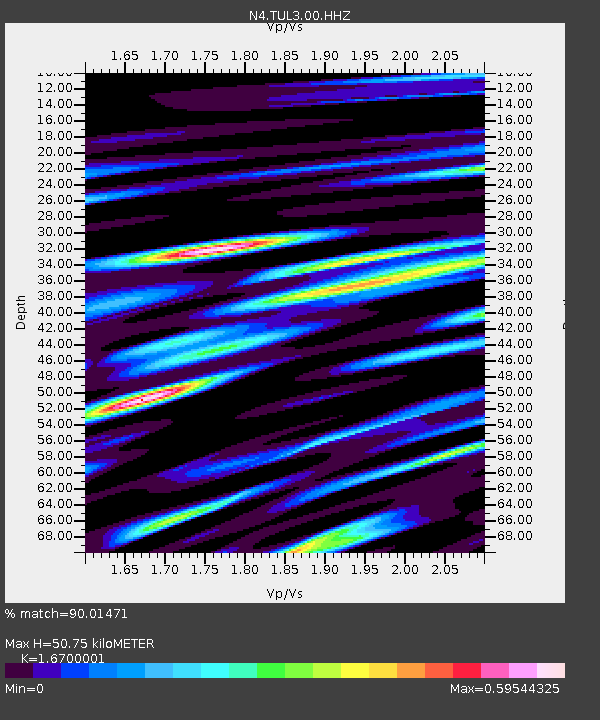
| Estimated Moho Depth: |
50.75 km |
| Estimated Crust Vp/Vs: |
1.67 |
| Assumed Crust Vp: |
6.498 km/s |
| Estimated Crust Vs: |
3.891 km/s |
| Estimated Crust Poisson's Ratio: |
0.22 |
|
| Radial Match: |
90.01471 % |
| Radial Bump: |
400 |
| Transverse Match: |
79.78419 % |
| Transverse Bump: |
400 |
| SOD ConfigId: |
22732711 |
| Insert Time: |
2020-10-15 02:07:13.057 +0000 |
| GWidth: |
2.5 |
| Max Bumps: |
400 |
| Tol: |
0.001 |
|

Signal To Noise
| Channel | StoN | STA | LTA |
| N4:TUL3:00:HHZ:20201001T01:26:13.018996Z | 17.000465 | 2.3477858E-6 | 1.3810126E-7 |
| N4:TUL3:00:HH1:20201001T01:26:13.018996Z | 2.726757 | 3.5856903E-7 | 1.3150017E-7 |
| N4:TUL3:00:HH2:20201001T01:26:13.018996Z | 7.7382355 | 7.592666E-7 | 9.811883E-8 |
| Arrivals |
| Ps | 5.4 SECOND |
| PpPs | 20 SECOND |
| PsPs/PpSs | 26 SECOND |


