You are here: Home > Network List > XT97 - Colorado BB Array - Lodore Stations List
> Station JWM XT.JWM > Earthquake Result Viewer
JWM XT.JWM - Earthquake Result Viewer
| Earthquake location: |
Fiji Islands Region |
| Earthquake latitude/longitude: |
-15.7/-179.3 |
| Earthquake time(UTC): |
1998/01/14 (014) 17:24:10 GMT |
| Earthquake Depth: |
33 km |
| Earthquake Magnitude: |
5.8 MB, 6.5 MS, 6.5 UNKNOWN, 6.5 MW |
| Earthquake Catalog/Contributor: |
WHDF/NEIC |
|
| Network: |
XT Colorado BB Array - Lodore |
| Station: |
JWM XT.JWM |
| Lat/Lon: |
40.57 N/108.60 W |
| Elevation: |
2077 m |
|
| Distance: |
86.1 deg |
| Az: |
46.112 deg |
| Baz: |
245.661 deg |
| Ray Param: |
0.0442324 |
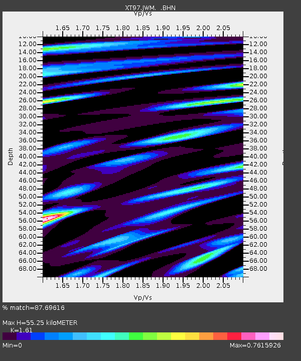
| Estimated Moho Depth: |
55.25 km |
| Estimated Crust Vp/Vs: |
1.61 |
| Assumed Crust Vp: |
6.207 km/s |
| Estimated Crust Vs: |
3.855 km/s |
| Estimated Crust Poisson's Ratio: |
0.19 |
|
| Radial Match: |
87.69616 % |
| Radial Bump: |
400 |
| Transverse Match: |
73.48392 % |
| Transverse Bump: |
400 |
| SOD ConfigId: |
6273 |
| Insert Time: |
2010-03-09 01:35:39.830 +0000 |
| GWidth: |
2.5 |
| Max Bumps: |
400 |
| Tol: |
0.001 |
|

Signal To Noise
| Channel | StoN | STA | LTA |
| XT:JWM: :BHN:19980114T17:36:16.724011Z | 0.9516802 | 1.8675676E-7 | 1.96239E-7 |
| XT:JWM: :BHE:19980114T17:36:16.724011Z | 0.60292435 | 1.5873717E-7 | 2.6327874E-7 |
| XT:JWM: :BHZ:19980114T17:36:16.724011Z | 2.5576723 | 5.223745E-7 | 2.0423825E-7 |
| Arrivals |
| Ps | 5.6 SECOND |
| PpPs | 23 SECOND |
| PsPs/PpSs | 28 SECOND |


