You are here: Home > Network List > NN - Western Great Basin/Eastern Sierra Nevada Stations List
> Station PRN Pahroc Range, Nevada. (GPS 12/04/2000) w84 > Earthquake Result Viewer
PRN Pahroc Range, Nevada. (GPS 12/04/2000) w84 - Earthquake Result Viewer
| Earthquake location: |
Tonga Islands |
| Earthquake latitude/longitude: |
-19.5/-174.2 |
| Earthquake time(UTC): |
2020/10/01 (275) 01:13:37 GMT |
| Earthquake Depth: |
35 km |
| Earthquake Magnitude: |
6.4 Mww |
| Earthquake Catalog/Contributor: |
NEIC PDE/us |
|
| Network: |
NN Western Great Basin/Eastern Sierra Nevada |
| Station: |
PRN Pahroc Range, Nevada. (GPS 12/04/2000) w84 |
| Lat/Lon: |
37.41 N/115.05 W |
| Elevation: |
1464 m |
|
| Distance: |
79.4 deg |
| Az: |
44.085 deg |
| Baz: |
235.509 deg |
| Ray Param: |
0.048955612 |
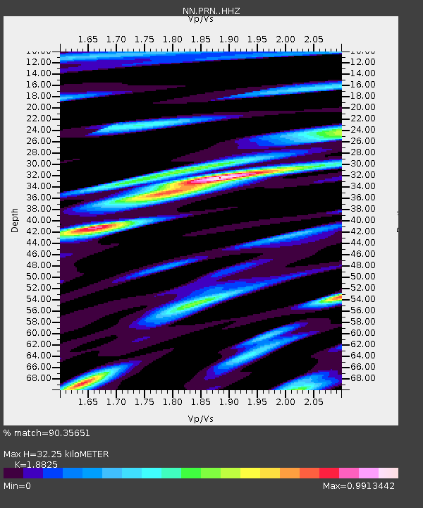
| Estimated Moho Depth: |
32.25 km |
| Estimated Crust Vp/Vs: |
1.88 |
| Assumed Crust Vp: |
6.276 km/s |
| Estimated Crust Vs: |
3.334 km/s |
| Estimated Crust Poisson's Ratio: |
0.30 |
|
| Radial Match: |
90.35651 % |
| Radial Bump: |
311 |
| Transverse Match: |
83.854355 % |
| Transverse Bump: |
400 |
| SOD ConfigId: |
22732711 |
| Insert Time: |
2020-10-15 02:08:01.049 +0000 |
| GWidth: |
2.5 |
| Max Bumps: |
400 |
| Tol: |
0.001 |
|

Signal To Noise
| Channel | StoN | STA | LTA |
| NN:PRN: :HHZ:20201001T01:25:09.099013Z | 20.911098 | 3.9131696E-6 | 1.8713362E-7 |
| NN:PRN: :HHN:20201001T01:25:09.099013Z | 8.402915 | 8.9259964E-7 | 1.06225E-7 |
| NN:PRN: :HHE:20201001T01:25:09.099013Z | 12.278534 | 1.5288697E-6 | 1.2451565E-7 |
| Arrivals |
| Ps | 4.7 SECOND |
| PpPs | 14 SECOND |
| PsPs/PpSs | 19 SECOND |


