You are here: Home > Network List > NN - Western Great Basin/Eastern Sierra Nevada Stations List
> Station QSM Queen of Sheba Mine, CA. (GPS 01/17/2001) w84gm > Earthquake Result Viewer
QSM Queen of Sheba Mine, CA. (GPS 01/17/2001) w84gm - Earthquake Result Viewer
| Earthquake location: |
Tonga Islands |
| Earthquake latitude/longitude: |
-19.5/-174.2 |
| Earthquake time(UTC): |
2020/10/01 (275) 01:13:37 GMT |
| Earthquake Depth: |
35 km |
| Earthquake Magnitude: |
6.4 Mww |
| Earthquake Catalog/Contributor: |
NEIC PDE/us |
|
| Network: |
NN Western Great Basin/Eastern Sierra Nevada |
| Station: |
QSM Queen of Sheba Mine, CA. (GPS 01/17/2001) w84gm |
| Lat/Lon: |
35.97 N/116.87 W |
| Elevation: |
385 m |
|
| Distance: |
77.4 deg |
| Az: |
44.433 deg |
| Baz: |
234.498 deg |
| Ray Param: |
0.050329294 |
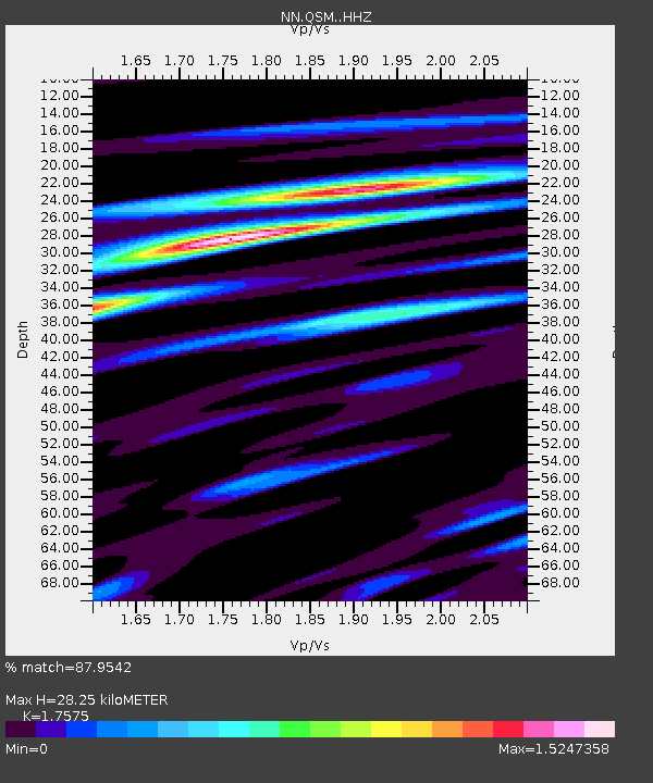
| Estimated Moho Depth: |
28.25 km |
| Estimated Crust Vp/Vs: |
1.76 |
| Assumed Crust Vp: |
6.276 km/s |
| Estimated Crust Vs: |
3.571 km/s |
| Estimated Crust Poisson's Ratio: |
0.26 |
|
| Radial Match: |
87.9542 % |
| Radial Bump: |
400 |
| Transverse Match: |
79.28321 % |
| Transverse Bump: |
400 |
| SOD ConfigId: |
22732711 |
| Insert Time: |
2020-10-15 02:08:07.074 +0000 |
| GWidth: |
2.5 |
| Max Bumps: |
400 |
| Tol: |
0.001 |
|

Signal To Noise
| Channel | StoN | STA | LTA |
| NN:QSM: :HHZ:20201001T01:24:57.96797Z | 33.167297 | 3.3572624E-6 | 1.01222064E-7 |
| NN:QSM: :HHN:20201001T01:24:57.96797Z | 6.7174044 | 8.484391E-7 | 1.263046E-7 |
| NN:QSM: :HHE:20201001T01:24:57.96797Z | 3.0884075 | 9.944799E-7 | 3.220041E-7 |
| Arrivals |
| Ps | 3.5 SECOND |
| PpPs | 12 SECOND |
| PsPs/PpSs | 16 SECOND |


