You are here: Home > Network List > NN - Western Great Basin/Eastern Sierra Nevada Stations List
> Station MCM05 Monte Cristo Menlo 05 > Earthquake Result Viewer
MCM05 Monte Cristo Menlo 05 - Earthquake Result Viewer
| Earthquake location: |
Tonga Islands |
| Earthquake latitude/longitude: |
-19.5/-174.2 |
| Earthquake time(UTC): |
2020/10/01 (275) 01:13:37 GMT |
| Earthquake Depth: |
35 km |
| Earthquake Magnitude: |
6.4 Mww |
| Earthquake Catalog/Contributor: |
NEIC PDE/us |
|
| Network: |
NN Western Great Basin/Eastern Sierra Nevada |
| Station: |
MCM05 Monte Cristo Menlo 05 |
| Lat/Lon: |
38.16 N/117.87 W |
| Elevation: |
1591 m |
|
| Distance: |
78.0 deg |
| Az: |
42.139 deg |
| Baz: |
233.406 deg |
| Ray Param: |
0.049901508 |
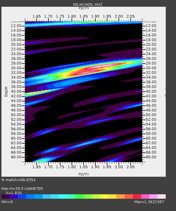
| Estimated Moho Depth: |
29.0 km |
| Estimated Crust Vp/Vs: |
1.92 |
| Assumed Crust Vp: |
6.276 km/s |
| Estimated Crust Vs: |
3.26 km/s |
| Estimated Crust Poisson's Ratio: |
0.32 |
|
| Radial Match: |
86.6354 % |
| Radial Bump: |
400 |
| Transverse Match: |
78.1442 % |
| Transverse Bump: |
400 |
| SOD ConfigId: |
22732711 |
| Insert Time: |
2020-10-15 02:08:28.468 +0000 |
| GWidth: |
2.5 |
| Max Bumps: |
400 |
| Tol: |
0.001 |
|

Signal To Noise
| Channel | StoN | STA | LTA |
| NN:MCM05: :HHZ:20201001T01:25:01.519972Z | 17.6471 | 4.0239365E-6 | 2.2802254E-7 |
| NN:MCM05: :HHN:20201001T01:25:01.519972Z | 3.1257331 | 7.6504324E-7 | 2.4475642E-7 |
| NN:MCM05: :HHE:20201001T01:25:01.519972Z | 6.5649548 | 1.2421254E-6 | 1.892055E-7 |
| Arrivals |
| Ps | 4.4 SECOND |
| PpPs | 13 SECOND |
| PsPs/PpSs | 18 SECOND |


