You are here: Home > Network List > XT97 - Colorado BB Array - Lodore Stations List
> Station JWM XT.JWM > Earthquake Result Viewer
JWM XT.JWM - Earthquake Result Viewer
| Earthquake location: |
Guatemala |
| Earthquake latitude/longitude: |
14.4/-91.5 |
| Earthquake time(UTC): |
1998/01/10 (010) 08:20:05 GMT |
| Earthquake Depth: |
33 km |
| Earthquake Magnitude: |
6.1 MB, 6.2 MS, 6.6 UNKNOWN, 6.6 ME |
| Earthquake Catalog/Contributor: |
WHDF/NEIC |
|
| Network: |
XT Colorado BB Array - Lodore |
| Station: |
JWM XT.JWM |
| Lat/Lon: |
40.57 N/108.60 W |
| Elevation: |
2077 m |
|
| Distance: |
30.1 deg |
| Az: |
333.411 deg |
| Baz: |
145.289 deg |
| Ray Param: |
0.079393625 |
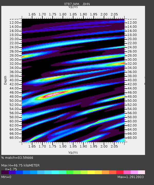
| Estimated Moho Depth: |
46.75 km |
| Estimated Crust Vp/Vs: |
1.75 |
| Assumed Crust Vp: |
6.207 km/s |
| Estimated Crust Vs: |
3.547 km/s |
| Estimated Crust Poisson's Ratio: |
0.26 |
|
| Radial Match: |
83.59666 % |
| Radial Bump: |
400 |
| Transverse Match: |
66.72011 % |
| Transverse Bump: |
400 |
| SOD ConfigId: |
4480 |
| Insert Time: |
2010-03-09 01:35:57.022 +0000 |
| GWidth: |
2.5 |
| Max Bumps: |
400 |
| Tol: |
0.001 |
|

Signal To Noise
| Channel | StoN | STA | LTA |
| XT:JWM: :BHN:19980110T08:25:41.775012Z | 13.051485 | 2.3486111E-6 | 1.7994972E-7 |
| XT:JWM: :BHE:19980110T08:25:41.775012Z | 8.655842 | 1.308678E-6 | 1.5119015E-7 |
| XT:JWM: :BHZ:19980110T08:25:41.775012Z | 5.940119 | 8.468667E-7 | 1.425673E-7 |
| Arrivals |
| Ps | 6.1 SECOND |
| PpPs | 19 SECOND |
| PsPs/PpSs | 25 SECOND |


