You are here: Home > Network List > O2 - Oklahoma Consolidated Temporary Seismic Networks Stations List
> Station FW06 Aline, Oklahoma, USA > Earthquake Result Viewer
FW06 Aline, Oklahoma, USA - Earthquake Result Viewer
| Earthquake location: |
Tonga Islands |
| Earthquake latitude/longitude: |
-19.5/-174.2 |
| Earthquake time(UTC): |
2020/10/01 (275) 01:13:37 GMT |
| Earthquake Depth: |
35 km |
| Earthquake Magnitude: |
6.4 Mww |
| Earthquake Catalog/Contributor: |
NEIC PDE/us |
|
| Network: |
O2 Oklahoma Consolidated Temporary Seismic Networks |
| Station: |
FW06 Aline, Oklahoma, USA |
| Lat/Lon: |
36.51 N/98.50 W |
| Elevation: |
420 m |
|
| Distance: |
90.5 deg |
| Az: |
51.332 deg |
| Baz: |
246.105 deg |
| Ray Param: |
0.04169343 |
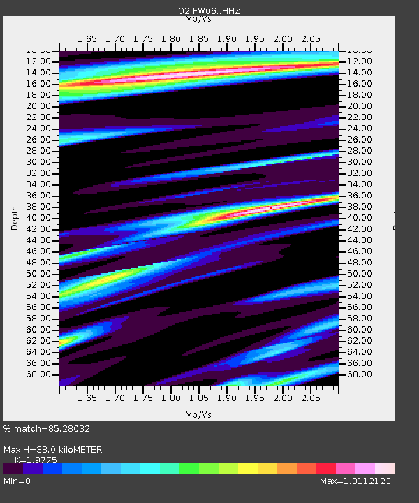
| Estimated Moho Depth: |
38.0 km |
| Estimated Crust Vp/Vs: |
1.98 |
| Assumed Crust Vp: |
6.426 km/s |
| Estimated Crust Vs: |
3.25 km/s |
| Estimated Crust Poisson's Ratio: |
0.33 |
|
| Radial Match: |
85.28032 % |
| Radial Bump: |
400 |
| Transverse Match: |
73.44369 % |
| Transverse Bump: |
400 |
| SOD ConfigId: |
22732711 |
| Insert Time: |
2020-10-15 02:09:17.030 +0000 |
| GWidth: |
2.5 |
| Max Bumps: |
400 |
| Tol: |
0.001 |
|

Signal To Noise
| Channel | StoN | STA | LTA |
| O2:FW06: :HHZ:20201001T01:26:04.815016Z | 14.805685 | 2.7781953E-6 | 1.876438E-7 |
| O2:FW06: :HHN:20201001T01:26:04.815016Z | 1.9936671 | 4.2279737E-7 | 2.1207019E-7 |
| O2:FW06: :HHE:20201001T01:26:04.815016Z | 3.709958 | 6.4807784E-7 | 1.7468602E-7 |
| Arrivals |
| Ps | 5.9 SECOND |
| PpPs | 17 SECOND |
| PsPs/PpSs | 23 SECOND |


