You are here: Home > Network List > O2 - Oklahoma Consolidated Temporary Seismic Networks Stations List
> Station FW09 Waynoka, Oklahoma, USA > Earthquake Result Viewer
FW09 Waynoka, Oklahoma, USA - Earthquake Result Viewer
| Earthquake location: |
Tonga Islands |
| Earthquake latitude/longitude: |
-19.5/-174.2 |
| Earthquake time(UTC): |
2020/10/01 (275) 01:13:37 GMT |
| Earthquake Depth: |
35 km |
| Earthquake Magnitude: |
6.4 Mww |
| Earthquake Catalog/Contributor: |
NEIC PDE/us |
|
| Network: |
O2 Oklahoma Consolidated Temporary Seismic Networks |
| Station: |
FW09 Waynoka, Oklahoma, USA |
| Lat/Lon: |
36.55 N/99.04 W |
| Elevation: |
517 m |
|
| Distance: |
90.1 deg |
| Az: |
51.121 deg |
| Baz: |
245.785 deg |
| Ray Param: |
0.041717544 |
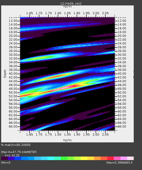
| Estimated Moho Depth: |
47.75 km |
| Estimated Crust Vp/Vs: |
1.81 |
| Assumed Crust Vp: |
6.426 km/s |
| Estimated Crust Vs: |
3.545 km/s |
| Estimated Crust Poisson's Ratio: |
0.28 |
|
| Radial Match: |
88.34885 % |
| Radial Bump: |
346 |
| Transverse Match: |
88.348854 % |
| Transverse Bump: |
346 |
| SOD ConfigId: |
22732711 |
| Insert Time: |
2020-10-15 02:09:19.726 +0000 |
| GWidth: |
2.5 |
| Max Bumps: |
400 |
| Tol: |
0.001 |
|

Signal To Noise
| Channel | StoN | STA | LTA |
| O2:FW09: :HHZ:20201001T01:26:03.044997Z | 17.376146 | 3.383388E-6 | 1.9471452E-7 |
| $trig.getChannelId() | $trig.getValue() | $trig.getSTA() | $trig.getLTA() |
| O2:FW09: :HHE:20201001T01:26:03.044997Z | 3.9828506 | 8.946417E-7 | 2.2462348E-7 |
| Arrivals |
| Ps | 6.2 SECOND |
| PpPs | 20 SECOND |
| PsPs/PpSs | 27 SECOND |


