You are here: Home > Network List > O2 - Oklahoma Consolidated Temporary Seismic Networks Stations List
> Station RNSP Roman Nose State Park, Oklahoma, USA > Earthquake Result Viewer
RNSP Roman Nose State Park, Oklahoma, USA - Earthquake Result Viewer
| Earthquake location: |
Tonga Islands |
| Earthquake latitude/longitude: |
-19.5/-174.2 |
| Earthquake time(UTC): |
2020/10/01 (275) 01:13:37 GMT |
| Earthquake Depth: |
35 km |
| Earthquake Magnitude: |
6.4 Mww |
| Earthquake Catalog/Contributor: |
NEIC PDE/us |
|
| Network: |
O2 Oklahoma Consolidated Temporary Seismic Networks |
| Station: |
RNSP Roman Nose State Park, Oklahoma, USA |
| Lat/Lon: |
35.93 N/98.43 W |
| Elevation: |
453 m |
|
| Distance: |
90.3 deg |
| Az: |
51.886 deg |
| Baz: |
246.144 deg |
| Ray Param: |
0.041705992 |
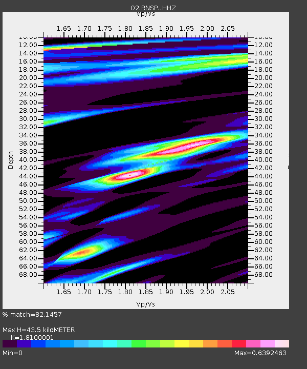
| Estimated Moho Depth: |
43.5 km |
| Estimated Crust Vp/Vs: |
1.81 |
| Assumed Crust Vp: |
6.315 km/s |
| Estimated Crust Vs: |
3.489 km/s |
| Estimated Crust Poisson's Ratio: |
0.28 |
|
| Radial Match: |
82.1457 % |
| Radial Bump: |
400 |
| Transverse Match: |
72.655106 % |
| Transverse Bump: |
400 |
| SOD ConfigId: |
22732711 |
| Insert Time: |
2020-10-15 02:09:51.834 +0000 |
| GWidth: |
2.5 |
| Max Bumps: |
400 |
| Tol: |
0.001 |
|

Signal To Noise
| Channel | StoN | STA | LTA |
| O2:RNSP: :HHZ:20201001T01:26:03.984999Z | 18.720125 | 3.2521405E-6 | 1.7372429E-7 |
| O2:RNSP: :HHN:20201001T01:26:03.984999Z | 2.109069 | 4.158383E-7 | 1.9716674E-7 |
| O2:RNSP: :HHE:20201001T01:26:03.984999Z | 2.7865245 | 7.2979077E-7 | 2.619E-7 |
| Arrivals |
| Ps | 5.7 SECOND |
| PpPs | 19 SECOND |
| PsPs/PpSs | 25 SECOND |


