You are here: Home > Network List > O2 - Oklahoma Consolidated Temporary Seismic Networks Stations List
> Station SC10 Scott, Oklahoma, USA > Earthquake Result Viewer
SC10 Scott, Oklahoma, USA - Earthquake Result Viewer
| Earthquake location: |
Tonga Islands |
| Earthquake latitude/longitude: |
-19.5/-174.2 |
| Earthquake time(UTC): |
2020/10/01 (275) 01:13:37 GMT |
| Earthquake Depth: |
35 km |
| Earthquake Magnitude: |
6.4 Mww |
| Earthquake Catalog/Contributor: |
NEIC PDE/us |
|
| Network: |
O2 Oklahoma Consolidated Temporary Seismic Networks |
| Station: |
SC10 Scott, Oklahoma, USA |
| Lat/Lon: |
35.42 N/98.27 W |
| Elevation: |
502 m |
|
| Distance: |
90.3 deg |
| Az: |
52.403 deg |
| Baz: |
246.231 deg |
| Ray Param: |
0.041711524 |
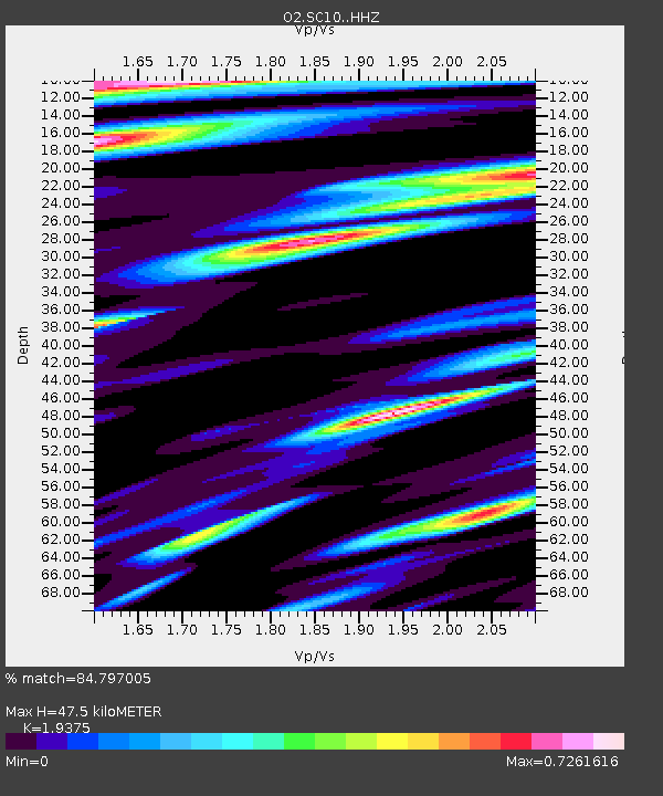
| Estimated Moho Depth: |
47.5 km |
| Estimated Crust Vp/Vs: |
1.94 |
| Assumed Crust Vp: |
6.315 km/s |
| Estimated Crust Vs: |
3.259 km/s |
| Estimated Crust Poisson's Ratio: |
0.32 |
|
| Radial Match: |
84.797005 % |
| Radial Bump: |
368 |
| Transverse Match: |
70.04732 % |
| Transverse Bump: |
362 |
| SOD ConfigId: |
22732711 |
| Insert Time: |
2020-10-15 02:10:03.510 +0000 |
| GWidth: |
2.5 |
| Max Bumps: |
400 |
| Tol: |
0.001 |
|

Signal To Noise
| Channel | StoN | STA | LTA |
| O2:SC10: :HHZ:20201001T01:26:03.560011Z | 20.654264 | 3.9773295E-6 | 1.92567E-7 |
| O2:SC10: :HHN:20201001T01:26:03.560011Z | 2.1765952 | 4.5333272E-7 | 2.0827609E-7 |
| O2:SC10: :HHE:20201001T01:26:03.560011Z | 4.573481 | 1.2670597E-6 | 2.7704493E-7 |
| Arrivals |
| Ps | 7.2 SECOND |
| PpPs | 22 SECOND |
| PsPs/PpSs | 29 SECOND |


