You are here: Home > Network List > O2 - Oklahoma Consolidated Temporary Seismic Networks Stations List
> Station SC19 Bison, Oklahoma, USA > Earthquake Result Viewer
SC19 Bison, Oklahoma, USA - Earthquake Result Viewer
| Earthquake location: |
Tonga Islands |
| Earthquake latitude/longitude: |
-19.5/-174.2 |
| Earthquake time(UTC): |
2020/10/01 (275) 01:13:37 GMT |
| Earthquake Depth: |
35 km |
| Earthquake Magnitude: |
6.4 Mww |
| Earthquake Catalog/Contributor: |
NEIC PDE/us |
|
| Network: |
O2 Oklahoma Consolidated Temporary Seismic Networks |
| Station: |
SC19 Bison, Oklahoma, USA |
| Lat/Lon: |
36.22 N/97.84 W |
| Elevation: |
1116 m |
|
| Distance: |
90.9 deg |
| Az: |
51.813 deg |
| Baz: |
246.486 deg |
| Ray Param: |
0.0416615 |
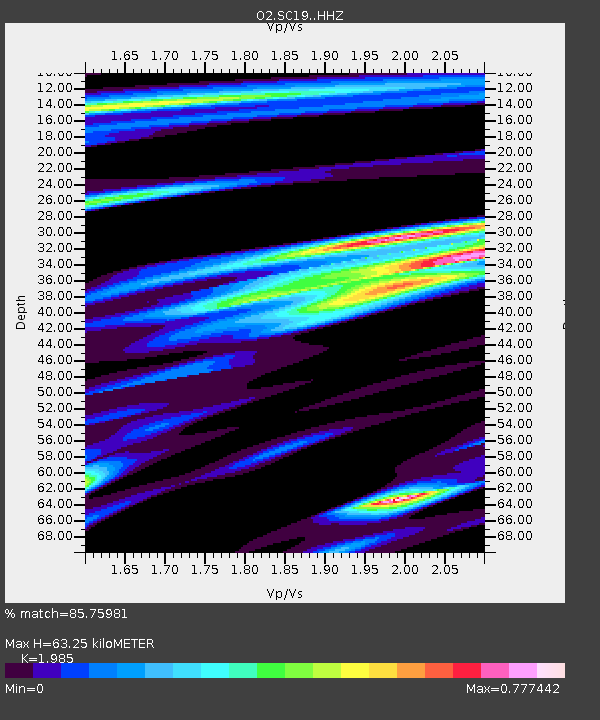
| Estimated Moho Depth: |
63.25 km |
| Estimated Crust Vp/Vs: |
1.99 |
| Assumed Crust Vp: |
6.483 km/s |
| Estimated Crust Vs: |
3.266 km/s |
| Estimated Crust Poisson's Ratio: |
0.33 |
|
| Radial Match: |
85.75981 % |
| Radial Bump: |
369 |
| Transverse Match: |
61.35375 % |
| Transverse Bump: |
400 |
| SOD ConfigId: |
22732711 |
| Insert Time: |
2020-10-15 02:10:14.850 +0000 |
| GWidth: |
2.5 |
| Max Bumps: |
400 |
| Tol: |
0.001 |
|

Signal To Noise
| Channel | StoN | STA | LTA |
| O2:SC19: :HHZ:20201001T01:26:06.515028Z | 10.558458 | 2.4269111E-6 | 2.2985469E-7 |
| O2:SC19: :HHN:20201001T01:26:06.515028Z | 0.78980005 | 1.641998E-7 | 2.0790047E-7 |
| O2:SC19: :HHE:20201001T01:26:06.515028Z | 6.4835587 | 1.0394441E-6 | 1.6032E-7 |
| Arrivals |
| Ps | 9.8 SECOND |
| PpPs | 29 SECOND |
| PsPs/PpSs | 38 SECOND |


