You are here: Home > Network List > O2 - Oklahoma Consolidated Temporary Seismic Networks Stations List
> Station TUTT Tuttle, Oklahoma, USA > Earthquake Result Viewer
TUTT Tuttle, Oklahoma, USA - Earthquake Result Viewer
| Earthquake location: |
Tonga Islands |
| Earthquake latitude/longitude: |
-19.5/-174.2 |
| Earthquake time(UTC): |
2020/10/01 (275) 01:13:37 GMT |
| Earthquake Depth: |
35 km |
| Earthquake Magnitude: |
6.4 Mww |
| Earthquake Catalog/Contributor: |
NEIC PDE/us |
|
| Network: |
O2 Oklahoma Consolidated Temporary Seismic Networks |
| Station: |
TUTT Tuttle, Oklahoma, USA |
| Lat/Lon: |
35.24 N/97.76 W |
| Elevation: |
407 m |
|
| Distance: |
90.6 deg |
| Az: |
52.74 deg |
| Baz: |
246.525 deg |
| Ray Param: |
0.04169022 |
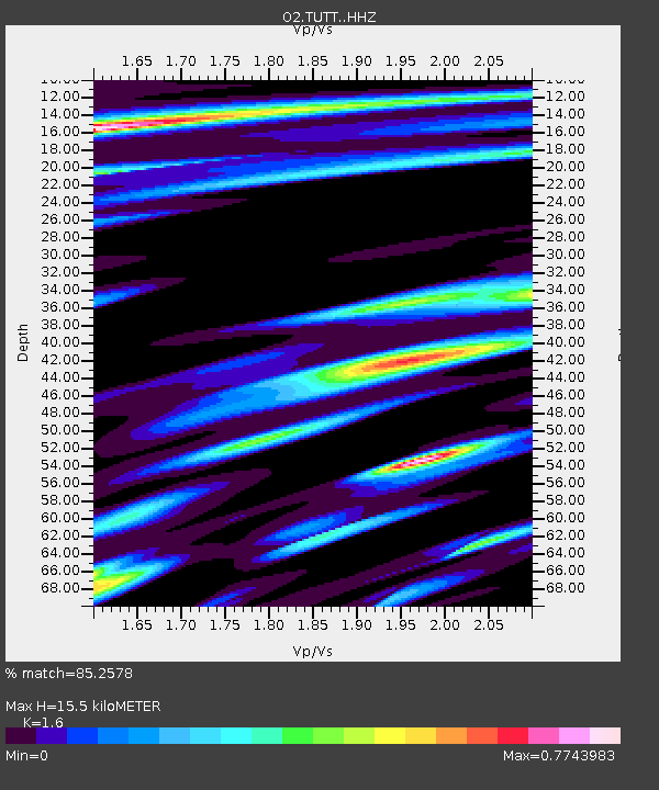
| Estimated Moho Depth: |
15.5 km |
| Estimated Crust Vp/Vs: |
1.60 |
| Assumed Crust Vp: |
6.426 km/s |
| Estimated Crust Vs: |
4.016 km/s |
| Estimated Crust Poisson's Ratio: |
0.18 |
|
| Radial Match: |
85.2578 % |
| Radial Bump: |
400 |
| Transverse Match: |
81.385 % |
| Transverse Bump: |
385 |
| SOD ConfigId: |
22732711 |
| Insert Time: |
2020-10-15 02:10:21.278 +0000 |
| GWidth: |
2.5 |
| Max Bumps: |
400 |
| Tol: |
0.001 |
|

Signal To Noise
| Channel | StoN | STA | LTA |
| O2:TUTT: :HHZ:20201001T01:26:05.010023Z | 16.82738 | 4.028098E-6 | 2.393776E-7 |
| O2:TUTT: :HHN:20201001T01:26:05.010023Z | 4.065899 | 8.803472E-7 | 2.165197E-7 |
| O2:TUTT: :HHE:20201001T01:26:05.010023Z | 1.4742855 | 5.9975844E-7 | 4.0681297E-7 |
| Arrivals |
| Ps | 1.5 SECOND |
| PpPs | 6.1 SECOND |
| PsPs/PpSs | 7.6 SECOND |


