You are here: Home > Network List > OK - Oklahoma Seismic Network Stations List
> Station W35A Tecumseh, Oklahoma, USA > Earthquake Result Viewer
W35A Tecumseh, Oklahoma, USA - Earthquake Result Viewer
| Earthquake location: |
Tonga Islands |
| Earthquake latitude/longitude: |
-19.5/-174.2 |
| Earthquake time(UTC): |
2020/10/01 (275) 01:13:37 GMT |
| Earthquake Depth: |
35 km |
| Earthquake Magnitude: |
6.4 Mww |
| Earthquake Catalog/Contributor: |
NEIC PDE/us |
|
| Network: |
OK Oklahoma Seismic Network |
| Station: |
W35A Tecumseh, Oklahoma, USA |
| Lat/Lon: |
35.15 N/96.87 W |
| Elevation: |
322 m |
|
| Distance: |
91.2 deg |
| Az: |
53.103 deg |
| Baz: |
247.025 deg |
| Ray Param: |
0.04162911 |
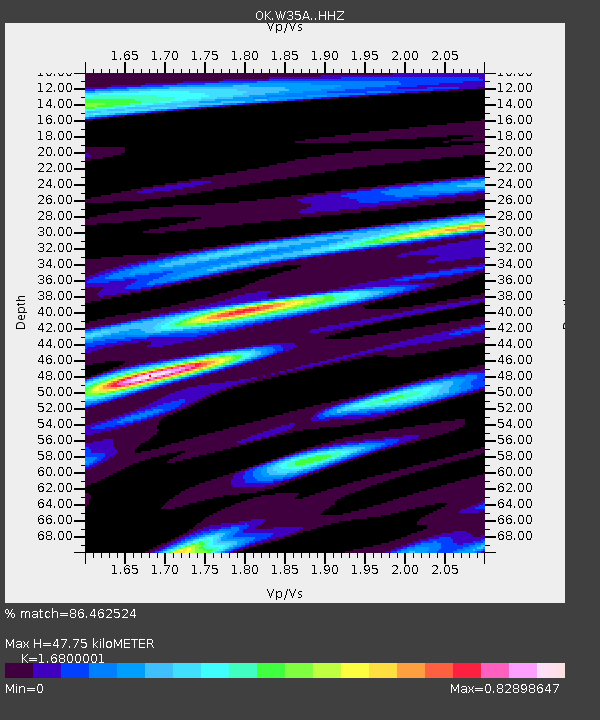
| Estimated Moho Depth: |
47.75 km |
| Estimated Crust Vp/Vs: |
1.68 |
| Assumed Crust Vp: |
6.426 km/s |
| Estimated Crust Vs: |
3.825 km/s |
| Estimated Crust Poisson's Ratio: |
0.23 |
|
| Radial Match: |
86.462524 % |
| Radial Bump: |
366 |
| Transverse Match: |
76.737434 % |
| Transverse Bump: |
311 |
| SOD ConfigId: |
22732711 |
| Insert Time: |
2020-10-15 02:10:44.973 +0000 |
| GWidth: |
2.5 |
| Max Bumps: |
400 |
| Tol: |
0.001 |
|

Signal To Noise
| Channel | StoN | STA | LTA |
| OK:W35A: :HHZ:20201001T01:26:07.914992Z | 24.787106 | 4.339624E-6 | 1.7507587E-7 |
| OK:W35A: :HHN:20201001T01:26:07.914992Z | 2.971268 | 4.830638E-7 | 1.6257832E-7 |
| OK:W35A: :HHE:20201001T01:26:07.914992Z | 4.907665 | 1.2428878E-6 | 2.5325443E-7 |
| Arrivals |
| Ps | 5.2 SECOND |
| PpPs | 19 SECOND |
| PsPs/PpSs | 25 SECOND |


