You are here: Home > Network List > RV - Regional Alberta Seismic Observatory for Earthquake Studies Network Stations List
> Station DEDWA Deadwood Lookout Tower, AB > Earthquake Result Viewer
DEDWA Deadwood Lookout Tower, AB - Earthquake Result Viewer
| Earthquake location: |
Tonga Islands |
| Earthquake latitude/longitude: |
-19.5/-174.2 |
| Earthquake time(UTC): |
2020/10/01 (275) 01:13:37 GMT |
| Earthquake Depth: |
35 km |
| Earthquake Magnitude: |
6.4 Mww |
| Earthquake Catalog/Contributor: |
NEIC PDE/us |
|
| Network: |
RV Regional Alberta Seismic Observatory for Earthquake Studies Network |
| Station: |
DEDWA Deadwood Lookout Tower, AB |
| Lat/Lon: |
56.64 N/117.39 W |
| Elevation: |
652 m |
|
| Distance: |
89.5 deg |
| Az: |
27.545 deg |
| Baz: |
232.161 deg |
| Ray Param: |
0.041753445 |
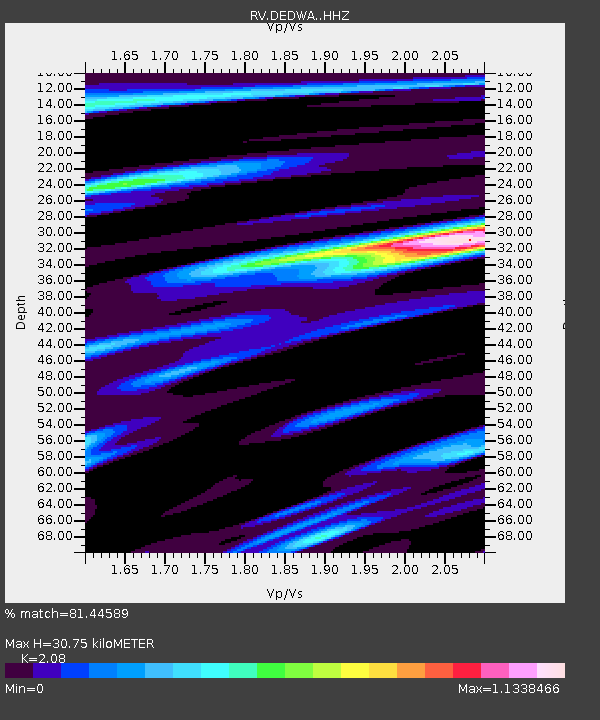
| Estimated Moho Depth: |
30.75 km |
| Estimated Crust Vp/Vs: |
2.08 |
| Assumed Crust Vp: |
6.444 km/s |
| Estimated Crust Vs: |
3.098 km/s |
| Estimated Crust Poisson's Ratio: |
0.35 |
|
| Radial Match: |
81.44589 % |
| Radial Bump: |
400 |
| Transverse Match: |
45.660477 % |
| Transverse Bump: |
400 |
| SOD ConfigId: |
22732711 |
| Insert Time: |
2020-10-15 02:11:58.360 +0000 |
| GWidth: |
2.5 |
| Max Bumps: |
400 |
| Tol: |
0.001 |
|

Signal To Noise
| Channel | StoN | STA | LTA |
| RV:DEDWA: :HHZ:20201001T01:26:00.120009Z | 20.68635 | 5.1184725E-6 | 2.4743235E-7 |
| RV:DEDWA: :HHN:20201001T01:26:00.120009Z | 1.0354543 | 1.2768145E-6 | 1.2330959E-6 |
| RV:DEDWA: :HHE:20201001T01:26:00.120009Z | 1.9118431 | 1.6291849E-6 | 8.5215413E-7 |
| Arrivals |
| Ps | 5.2 SECOND |
| PpPs | 14 SECOND |
| PsPs/PpSs | 20 SECOND |


