You are here: Home > Network List > TA - USArray Transportable Network (new EarthScope stations) Stations List
> Station F24K Squaw Lake, AK, USA > Earthquake Result Viewer
F24K Squaw Lake, AK, USA - Earthquake Result Viewer
| Earthquake location: |
Tonga Islands |
| Earthquake latitude/longitude: |
-19.5/-174.2 |
| Earthquake time(UTC): |
2020/10/01 (275) 01:13:37 GMT |
| Earthquake Depth: |
35 km |
| Earthquake Magnitude: |
6.4 Mww |
| Earthquake Catalog/Contributor: |
NEIC PDE/us |
|
| Network: |
TA USArray Transportable Network (new EarthScope stations) |
| Station: |
F24K Squaw Lake, AK, USA |
| Lat/Lon: |
67.52 N/147.89 W |
| Elevation: |
736 m |
|
| Distance: |
88.9 deg |
| Az: |
9.826 deg |
| Baz: |
204.748 deg |
| Ray Param: |
0.04219122 |
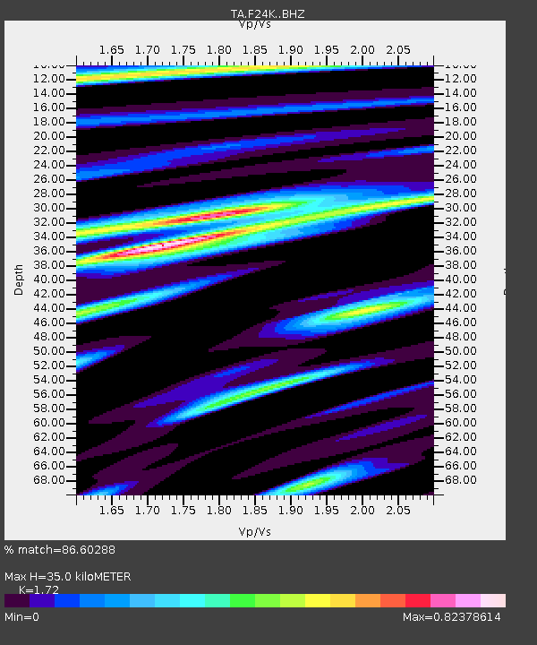
| Estimated Moho Depth: |
35.0 km |
| Estimated Crust Vp/Vs: |
1.72 |
| Assumed Crust Vp: |
6.522 km/s |
| Estimated Crust Vs: |
3.792 km/s |
| Estimated Crust Poisson's Ratio: |
0.24 |
|
| Radial Match: |
86.60288 % |
| Radial Bump: |
400 |
| Transverse Match: |
79.52826 % |
| Transverse Bump: |
399 |
| SOD ConfigId: |
22732711 |
| Insert Time: |
2020-10-15 02:13:41.090 +0000 |
| GWidth: |
2.5 |
| Max Bumps: |
400 |
| Tol: |
0.001 |
|
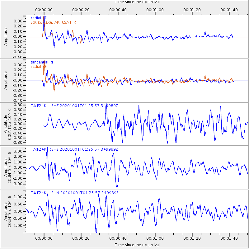
Signal To Noise
| Channel | StoN | STA | LTA |
| TA:F24K: :BHZ:20201001T01:25:57.349989Z | 12.191167 | 1.4931894E-6 | 1.2248125E-7 |
| TA:F24K: :BHN:20201001T01:25:57.349989Z | 3.3312216 | 5.2258247E-7 | 1.5687412E-7 |
| TA:F24K: :BHE:20201001T01:25:57.349989Z | 1.9831544 | 2.9150027E-7 | 1.469882E-7 |
| Arrivals |
| Ps | 4.0 SECOND |
| PpPs | 14 SECOND |
| PsPs/PpSs | 18 SECOND |


