You are here: Home > Network List > TA - USArray Transportable Network (new EarthScope stations) Stations List
> Station M31M Drury Creek, Yukon, CA > Earthquake Result Viewer
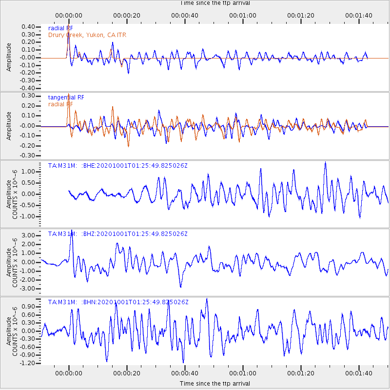
M31M Drury Creek, Yukon, CA - Earthquake Result Viewer
*The percent match for this event was below the threshold and hence no stack was calculated.
| Earthquake location: |
Tonga Islands |
| Earthquake latitude/longitude: |
-19.5/-174.2 |
| Earthquake time(UTC): |
2020/10/01 (275) 01:13:37 GMT |
| Earthquake Depth: |
35 km |
| Earthquake Magnitude: |
6.4 Mww |
| Earthquake Catalog/Contributor: |
NEIC PDE/us |
|
| Network: |
TA USArray Transportable Network (new EarthScope stations) |
| Station: |
M31M Drury Creek, Yukon, CA |
| Lat/Lon: |
62.20 N/134.39 W |
| Elevation: |
639 m |
|
| Distance: |
87.3 deg |
| Az: |
17.495 deg |
| Baz: |
217.226 deg |
| Ray Param: |
$rayparam |
*The percent match for this event was below the threshold and hence was not used in the summary stack. |
|
| Radial Match: |
78.24329 % |
| Radial Bump: |
400 |
| Transverse Match: |
69.12228 % |
| Transverse Bump: |
400 |
| SOD ConfigId: |
22732711 |
| Insert Time: |
2020-10-15 02:14:39.934 +0000 |
| GWidth: |
2.5 |
| Max Bumps: |
400 |
| Tol: |
0.001 |
|
Signal To Noise
| Channel | StoN | STA | LTA |
| TA:M31M: :BHZ:20201001T01:25:49.825026Z | 5.403521 | 1.4621131E-6 | 2.7058525E-7 |
| TA:M31M: :BHN:20201001T01:25:49.825026Z | 2.0814502 | 4.3704762E-7 | 2.0997267E-7 |
| TA:M31M: :BHE:20201001T01:25:49.825026Z | 3.210584 | 4.479202E-7 | 1.3951363E-7 |
| Arrivals |
| Ps | |
| PpPs | |
| PsPs/PpSs | |


