You are here: Home > Network List > TA - USArray Transportable Network (new EarthScope stations) Stations List
> Station O28M Mount Upton, YT, CAN > Earthquake Result Viewer
O28M Mount Upton, YT, CAN - Earthquake Result Viewer
| Earthquake location: |
Tonga Islands |
| Earthquake latitude/longitude: |
-19.5/-174.2 |
| Earthquake time(UTC): |
2020/10/01 (275) 01:13:37 GMT |
| Earthquake Depth: |
35 km |
| Earthquake Magnitude: |
6.4 Mww |
| Earthquake Catalog/Contributor: |
NEIC PDE/us |
|
| Network: |
TA USArray Transportable Network (new EarthScope stations) |
| Station: |
O28M Mount Upton, YT, CAN |
| Lat/Lon: |
60.77 N/140.19 W |
| Elevation: |
2622 m |
|
| Distance: |
84.6 deg |
| Az: |
16.018 deg |
| Baz: |
212.031 deg |
| Ray Param: |
0.04534659 |
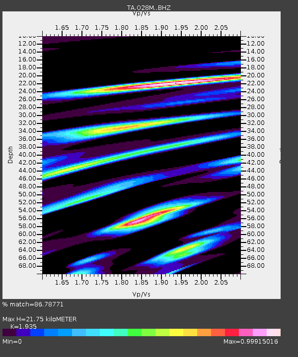
| Estimated Moho Depth: |
21.75 km |
| Estimated Crust Vp/Vs: |
1.93 |
| Assumed Crust Vp: |
6.566 km/s |
| Estimated Crust Vs: |
3.393 km/s |
| Estimated Crust Poisson's Ratio: |
0.32 |
|
| Radial Match: |
86.78771 % |
| Radial Bump: |
400 |
| Transverse Match: |
78.09625 % |
| Transverse Bump: |
400 |
| SOD ConfigId: |
22732711 |
| Insert Time: |
2020-10-15 02:14:53.694 +0000 |
| GWidth: |
2.5 |
| Max Bumps: |
400 |
| Tol: |
0.001 |
|
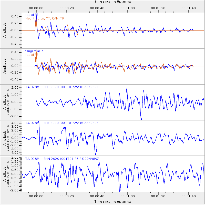
Signal To Noise
| Channel | StoN | STA | LTA |
| TA:O28M: :BHZ:20201001T01:25:36.224989Z | 7.3809443 | 1.8980835E-6 | 2.5715997E-7 |
| TA:O28M: :BHN:20201001T01:25:36.224989Z | 3.5172298 | 7.085851E-7 | 2.0146113E-7 |
| TA:O28M: :BHE:20201001T01:25:36.224989Z | 1.7567499 | 4.4818165E-7 | 2.5511977E-7 |
| Arrivals |
| Ps | 3.2 SECOND |
| PpPs | 9.5 SECOND |
| PsPs/PpSs | 13 SECOND |


