You are here: Home > Network List > XT97 - Colorado BB Array - Lodore Stations List
> Station KINN XT.KINN > Earthquake Result Viewer
KINN XT.KINN - Earthquake Result Viewer
| Earthquake location: |
South Of Fiji Islands |
| Earthquake latitude/longitude: |
-22.1/-176.8 |
| Earthquake time(UTC): |
1997/10/14 (287) 09:53:18 GMT |
| Earthquake Depth: |
167 km |
| Earthquake Magnitude: |
6.7 MB, 7.7 UNKNOWN, 7.4 ME |
| Earthquake Catalog/Contributor: |
WHDF/NEIC |
|
| Network: |
XT Colorado BB Array - Lodore |
| Station: |
KINN XT.KINN |
| Lat/Lon: |
41.18 N/108.59 W |
| Elevation: |
2292 m |
|
| Distance: |
89.1 deg |
| Az: |
44.493 deg |
| Baz: |
239.434 deg |
| Ray Param: |
0.041729573 |
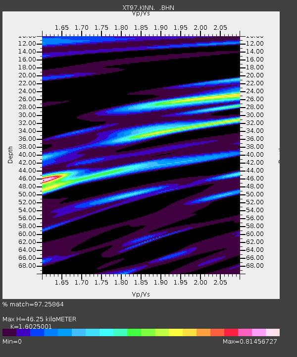
| Estimated Moho Depth: |
46.25 km |
| Estimated Crust Vp/Vs: |
1.60 |
| Assumed Crust Vp: |
6.207 km/s |
| Estimated Crust Vs: |
3.873 km/s |
| Estimated Crust Poisson's Ratio: |
0.18 |
|
| Radial Match: |
97.25864 % |
| Radial Bump: |
400 |
| Transverse Match: |
94.59696 % |
| Transverse Bump: |
400 |
| SOD ConfigId: |
6273 |
| Insert Time: |
2010-03-09 01:36:31.459 +0000 |
| GWidth: |
2.5 |
| Max Bumps: |
400 |
| Tol: |
0.001 |
|

Signal To Noise
| Channel | StoN | STA | LTA |
| XT:KINN: :BHN:19971014T10:05:23.399011Z | 1.9347239 | 4.116497E-7 | 2.1276924E-7 |
| XT:KINN: :BHE:19971014T10:05:23.399011Z | 2.011473 | 3.5658093E-7 | 1.7727353E-7 |
| XT:KINN: :BHZ:19971014T10:05:23.399011Z | 5.4326563 | 1.2431982E-6 | 2.28838E-7 |
| Arrivals |
| Ps | 4.6 SECOND |
| PpPs | 19 SECOND |
| PsPs/PpSs | 24 SECOND |


