You are here: Home > Network List > TA - USArray Transportable Network (new EarthScope stations) Stations List
> Station R31K City Hall, Gustavus, AK, USA > Earthquake Result Viewer
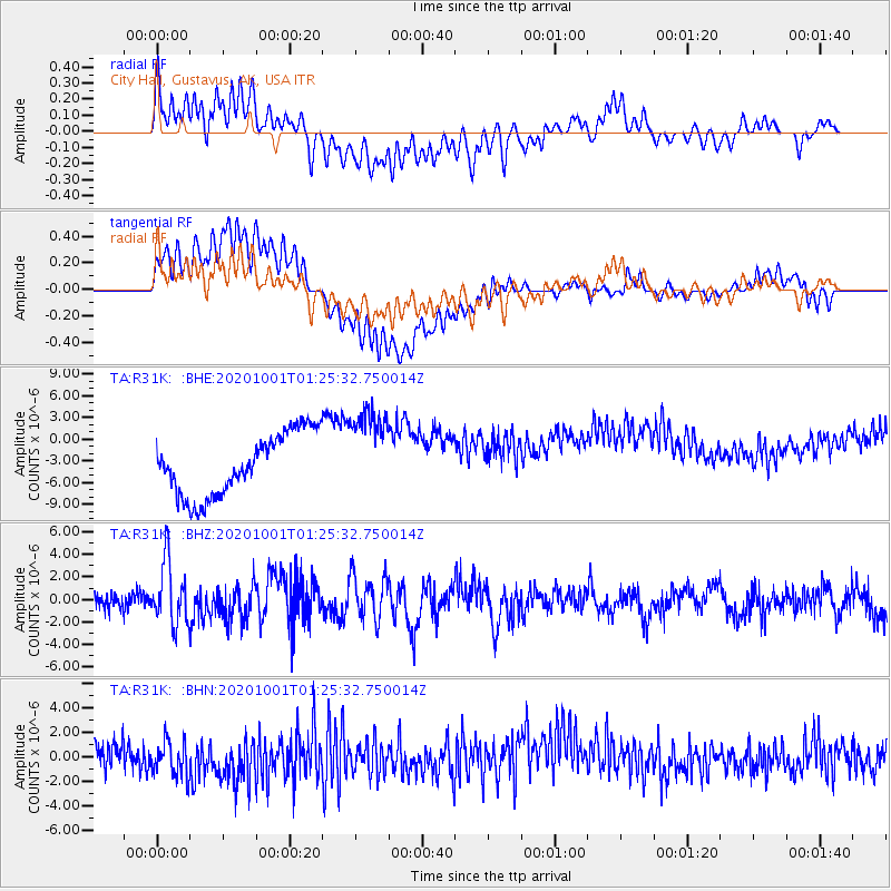
R31K City Hall, Gustavus, AK, USA - Earthquake Result Viewer
*The percent match for this event was below the threshold and hence no stack was calculated.
| Earthquake location: |
Tonga Islands |
| Earthquake latitude/longitude: |
-19.5/-174.2 |
| Earthquake time(UTC): |
2020/10/01 (275) 01:13:37 GMT |
| Earthquake Depth: |
35 km |
| Earthquake Magnitude: |
6.4 Mww |
| Earthquake Catalog/Contributor: |
NEIC PDE/us |
|
| Network: |
TA USArray Transportable Network (new EarthScope stations) |
| Station: |
R31K City Hall, Gustavus, AK, USA |
| Lat/Lon: |
58.41 N/135.74 W |
| Elevation: |
15 m |
|
| Distance: |
83.9 deg |
| Az: |
19.234 deg |
| Baz: |
216.188 deg |
| Ray Param: |
$rayparam |
*The percent match for this event was below the threshold and hence was not used in the summary stack. |
|
| Radial Match: |
23.299887 % |
| Radial Bump: |
400 |
| Transverse Match: |
19.290997 % |
| Transverse Bump: |
400 |
| SOD ConfigId: |
22732711 |
| Insert Time: |
2020-10-15 02:15:04.733 +0000 |
| GWidth: |
2.5 |
| Max Bumps: |
400 |
| Tol: |
0.001 |
|
Signal To Noise
| Channel | StoN | STA | LTA |
| TA:R31K: :BHZ:20201001T01:25:32.750014Z | 3.078577 | 2.7627727E-6 | 8.974187E-7 |
| TA:R31K: :BHN:20201001T01:25:32.750014Z | 0.9442155 | 1.6445265E-6 | 1.7416857E-6 |
| TA:R31K: :BHE:20201001T01:25:32.750014Z | 1.4540818 | 6.1891333E-6 | 4.256386E-6 |
| Arrivals |
| Ps | |
| PpPs | |
| PsPs/PpSs | |


