You are here: Home > Network List > TX - Texas Seismological Network Stations List
> Station FW01 Dallas Executive Airport > Earthquake Result Viewer
FW01 Dallas Executive Airport - Earthquake Result Viewer
| Earthquake location: |
Tonga Islands |
| Earthquake latitude/longitude: |
-19.5/-174.2 |
| Earthquake time(UTC): |
2020/10/01 (275) 01:13:37 GMT |
| Earthquake Depth: |
35 km |
| Earthquake Magnitude: |
6.4 Mww |
| Earthquake Catalog/Contributor: |
NEIC PDE/us |
|
| Network: |
TX Texas Seismological Network |
| Station: |
FW01 Dallas Executive Airport |
| Lat/Lon: |
32.68 N/96.88 W |
| Elevation: |
203 m |
|
| Distance: |
90.2 deg |
| Az: |
55.369 deg |
| Baz: |
246.995 deg |
| Ray Param: |
0.041712806 |
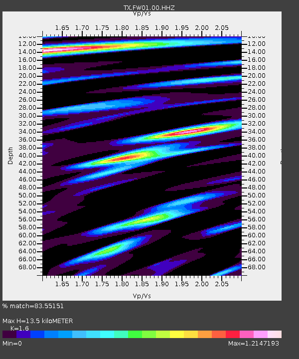
| Estimated Moho Depth: |
13.5 km |
| Estimated Crust Vp/Vs: |
1.60 |
| Assumed Crust Vp: |
6.38 km/s |
| Estimated Crust Vs: |
3.988 km/s |
| Estimated Crust Poisson's Ratio: |
0.18 |
|
| Radial Match: |
83.55151 % |
| Radial Bump: |
400 |
| Transverse Match: |
75.78711 % |
| Transverse Bump: |
400 |
| SOD ConfigId: |
22732711 |
| Insert Time: |
2020-10-15 02:16:05.611 +0000 |
| GWidth: |
2.5 |
| Max Bumps: |
400 |
| Tol: |
0.001 |
|

Signal To Noise
| Channel | StoN | STA | LTA |
| TX:FW01:00:HHZ:20201001T01:26:03.459975Z | 10.599204 | 2.9172036E-6 | 2.7522856E-7 |
| TX:FW01:00:HH1:20201001T01:26:03.459975Z | 2.9814882 | 6.50821E-7 | 2.1828731E-7 |
| TX:FW01:00:HH2:20201001T01:26:03.459975Z | 4.045822 | 9.53427E-7 | 2.3565717E-7 |
| Arrivals |
| Ps | 1.3 SECOND |
| PpPs | 5.4 SECOND |
| PsPs/PpSs | 6.7 SECOND |


