You are here: Home > Network List > TX - Texas Seismological Network Stations List
> Station FW11 UT at Arlington > Earthquake Result Viewer
FW11 UT at Arlington - Earthquake Result Viewer
| Earthquake location: |
Tonga Islands |
| Earthquake latitude/longitude: |
-19.5/-174.2 |
| Earthquake time(UTC): |
2020/10/01 (275) 01:13:37 GMT |
| Earthquake Depth: |
35 km |
| Earthquake Magnitude: |
6.4 Mww |
| Earthquake Catalog/Contributor: |
NEIC PDE/us |
|
| Network: |
TX Texas Seismological Network |
| Station: |
FW11 UT at Arlington |
| Lat/Lon: |
32.72 N/97.13 W |
| Elevation: |
198 m |
|
| Distance: |
90.1 deg |
| Az: |
55.251 deg |
| Baz: |
246.861 deg |
| Ray Param: |
0.041721664 |
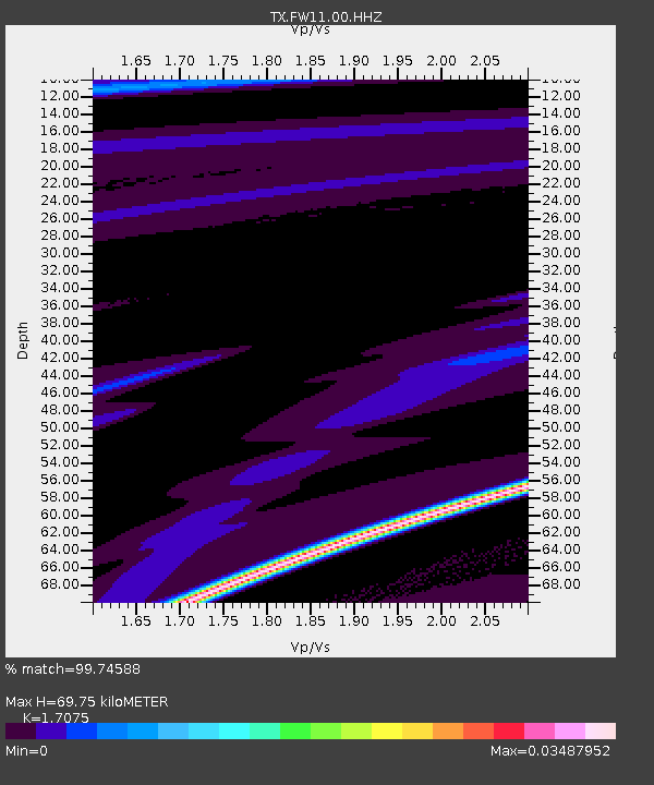
| Estimated Moho Depth: |
69.75 km |
| Estimated Crust Vp/Vs: |
1.71 |
| Assumed Crust Vp: |
6.38 km/s |
| Estimated Crust Vs: |
3.737 km/s |
| Estimated Crust Poisson's Ratio: |
0.24 |
|
| Radial Match: |
99.74588 % |
| Radial Bump: |
25 |
| Transverse Match: |
99.71601 % |
| Transverse Bump: |
37 |
| SOD ConfigId: |
22732711 |
| Insert Time: |
2020-10-15 02:16:14.067 +0000 |
| GWidth: |
2.5 |
| Max Bumps: |
400 |
| Tol: |
0.001 |
|
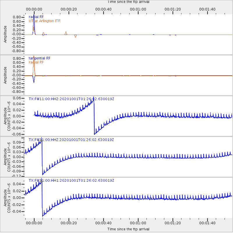
Signal To Noise
| Channel | StoN | STA | LTA |
| TX:FW11:00:HHZ:20201001T01:26:02.630019Z | 8.350729 | 7.497816E-8 | 8.9786365E-9 |
| TX:FW11:00:HH1:20201001T01:26:02.630019Z | 8.179343 | 3.588435E-8 | 4.3871924E-9 |
| TX:FW11:00:HH2:20201001T01:26:02.630019Z | 7.936524 | 3.9737298E-8 | 5.0068896E-9 |
| Arrivals |
| Ps | 7.9 SECOND |
| PpPs | 29 SECOND |
| PsPs/PpSs | 37 SECOND |


