You are here: Home > Network List > TX - Texas Seismological Network Stations List
> Station MB02 Rankin > Earthquake Result Viewer
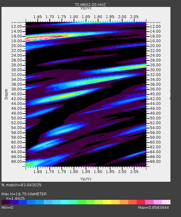
MB02 Rankin - Earthquake Result Viewer
| Earthquake location: |
Tonga Islands |
| Earthquake latitude/longitude: |
-19.5/-174.2 |
| Earthquake time(UTC): |
2020/10/01 (275) 01:13:37 GMT |
| Earthquake Depth: |
35 km |
| Earthquake Magnitude: |
6.4 Mww |
| Earthquake Catalog/Contributor: |
NEIC PDE/us |
|
| Network: |
TX Texas Seismological Network |
| Station: |
MB02 Rankin |
| Lat/Lon: |
31.20 N/102.04 W |
| Elevation: |
768 m |
|
| Distance: |
85.6 deg |
| Az: |
54.907 deg |
| Baz: |
244.26 deg |
| Ray Param: |
0.044585224 |
| Estimated Moho Depth: |
16.75 km |
| Estimated Crust Vp/Vs: |
1.64 |
| Assumed Crust Vp: |
6.121 km/s |
| Estimated Crust Vs: |
3.726 km/s |
| Estimated Crust Poisson's Ratio: |
0.21 |
|
| Radial Match: |
93.843025 % |
| Radial Bump: |
400 |
| Transverse Match: |
90.52564 % |
| Transverse Bump: |
400 |
| SOD ConfigId: |
22732711 |
| Insert Time: |
2020-10-15 02:16:27.894 +0000 |
| GWidth: |
2.5 |
| Max Bumps: |
400 |
| Tol: |
0.001 |
|

Signal To Noise
| Channel | StoN | STA | LTA |
| TX:MB02:00:HHZ:20201001T01:25:41.490004Z | 33.613598 | 2.9467305E-6 | 8.7664844E-8 |
| TX:MB02:00:HH1:20201001T01:25:41.490004Z | 8.324866 | 6.7085875E-7 | 8.058493E-8 |
| TX:MB02:00:HH2:20201001T01:25:41.490004Z | 12.954915 | 7.357441E-7 | 5.679266E-8 |
| Arrivals |
| Ps | 1.8 SECOND |
| PpPs | 7.1 SECOND |
| PsPs/PpSs | 8.9 SECOND |


