You are here: Home > Network List > TX - Texas Seismological Network Stations List
> Station MB04 Seminole > Earthquake Result Viewer
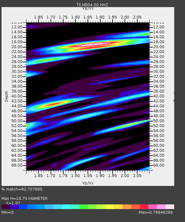
MB04 Seminole - Earthquake Result Viewer
| Earthquake location: |
Tonga Islands |
| Earthquake latitude/longitude: |
-19.5/-174.2 |
| Earthquake time(UTC): |
2020/10/01 (275) 01:13:37 GMT |
| Earthquake Depth: |
35 km |
| Earthquake Magnitude: |
6.4 Mww |
| Earthquake Catalog/Contributor: |
NEIC PDE/us |
|
| Network: |
TX Texas Seismological Network |
| Station: |
MB04 Seminole |
| Lat/Lon: |
32.63 N/102.49 W |
| Elevation: |
956 m |
|
| Distance: |
85.9 deg |
| Az: |
53.456 deg |
| Baz: |
243.916 deg |
| Ray Param: |
0.044391755 |
| Estimated Moho Depth: |
18.75 km |
| Estimated Crust Vp/Vs: |
1.87 |
| Assumed Crust Vp: |
6.129 km/s |
| Estimated Crust Vs: |
3.277 km/s |
| Estimated Crust Poisson's Ratio: |
0.30 |
|
| Radial Match: |
92.707985 % |
| Radial Bump: |
311 |
| Transverse Match: |
77.1608 % |
| Transverse Bump: |
400 |
| SOD ConfigId: |
22732711 |
| Insert Time: |
2020-10-15 02:16:30.345 +0000 |
| GWidth: |
2.5 |
| Max Bumps: |
400 |
| Tol: |
0.001 |
|

Signal To Noise
| Channel | StoN | STA | LTA |
| TX:MB04:00:HHZ:20201001T01:25:42.859999Z | 44.091263 | 4.308848E-6 | 9.772567E-8 |
| TX:MB04:00:HH1:20201001T01:25:42.859999Z | 7.9405246 | 8.7306285E-7 | 1.0995027E-7 |
| TX:MB04:00:HH2:20201001T01:25:42.859999Z | 22.27977 | 1.6085046E-6 | 7.2195746E-8 |
| Arrivals |
| Ps | 2.7 SECOND |
| PpPs | 8.6 SECOND |
| PsPs/PpSs | 11 SECOND |


