You are here: Home > Network List > TX - Texas Seismological Network Stations List
> Station MNHN Monahans > Earthquake Result Viewer
MNHN Monahans - Earthquake Result Viewer
| Earthquake location: |
Tonga Islands |
| Earthquake latitude/longitude: |
-19.5/-174.2 |
| Earthquake time(UTC): |
2020/10/01 (275) 01:13:37 GMT |
| Earthquake Depth: |
35 km |
| Earthquake Magnitude: |
6.4 Mww |
| Earthquake Catalog/Contributor: |
NEIC PDE/us |
|
| Network: |
TX Texas Seismological Network |
| Station: |
MNHN Monahans |
| Lat/Lon: |
31.34 N/102.76 W |
| Elevation: |
750 m |
|
| Distance: |
85.1 deg |
| Az: |
54.508 deg |
| Baz: |
243.854 deg |
| Ray Param: |
0.044941638 |
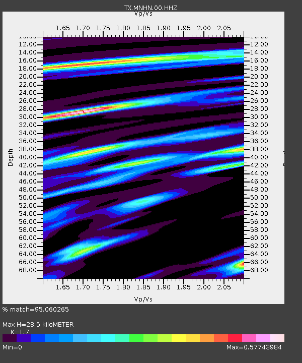
| Estimated Moho Depth: |
28.5 km |
| Estimated Crust Vp/Vs: |
1.70 |
| Assumed Crust Vp: |
6.121 km/s |
| Estimated Crust Vs: |
3.6 km/s |
| Estimated Crust Poisson's Ratio: |
0.24 |
|
| Radial Match: |
95.060265 % |
| Radial Bump: |
266 |
| Transverse Match: |
90.39733 % |
| Transverse Bump: |
368 |
| SOD ConfigId: |
22732711 |
| Insert Time: |
2020-10-15 02:16:36.230 +0000 |
| GWidth: |
2.5 |
| Max Bumps: |
400 |
| Tol: |
0.001 |
|

Signal To Noise
| Channel | StoN | STA | LTA |
| TX:MNHN:00:HHZ:20201001T01:25:39.034987Z | 45.22495 | 5.470962E-6 | 1.2097222E-7 |
| TX:MNHN:00:HH1:20201001T01:25:39.034987Z | 18.0113 | 1.8324685E-6 | 1.0173994E-7 |
| TX:MNHN:00:HH2:20201001T01:25:39.034987Z | 3.390875 | 4.385623E-7 | 1.2933602E-7 |
| Arrivals |
| Ps | 3.3 SECOND |
| PpPs | 12 SECOND |
| PsPs/PpSs | 16 SECOND |


