You are here: Home > Network List > TX - Texas Seismological Network Stations List
> Station PB14 Weatherby Road > Earthquake Result Viewer
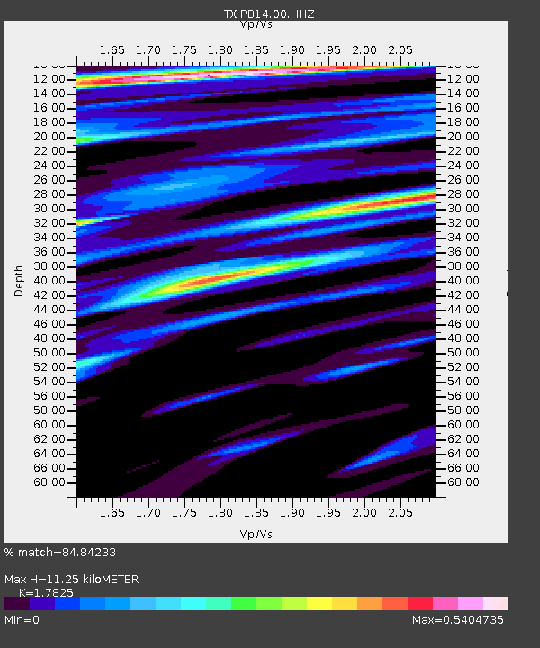
PB14 Weatherby Road - Earthquake Result Viewer
| Earthquake location: |
Tonga Islands |
| Earthquake latitude/longitude: |
-19.5/-174.2 |
| Earthquake time(UTC): |
2020/10/01 (275) 01:13:37 GMT |
| Earthquake Depth: |
35 km |
| Earthquake Magnitude: |
6.4 Mww |
| Earthquake Catalog/Contributor: |
NEIC PDE/us |
|
| Network: |
TX Texas Seismological Network |
| Station: |
PB14 Weatherby Road |
| Lat/Lon: |
31.13 N/103.15 W |
| Elevation: |
807 m |
|
| Distance: |
84.7 deg |
| Az: |
54.549 deg |
| Baz: |
243.657 deg |
| Ray Param: |
0.04522617 |
| Estimated Moho Depth: |
11.25 km |
| Estimated Crust Vp/Vs: |
1.78 |
| Assumed Crust Vp: |
6.121 km/s |
| Estimated Crust Vs: |
3.434 km/s |
| Estimated Crust Poisson's Ratio: |
0.27 |
|
| Radial Match: |
84.84233 % |
| Radial Bump: |
400 |
| Transverse Match: |
70.53086 % |
| Transverse Bump: |
400 |
| SOD ConfigId: |
22732711 |
| Insert Time: |
2020-10-15 02:16:56.044 +0000 |
| GWidth: |
2.5 |
| Max Bumps: |
400 |
| Tol: |
0.001 |
|

Signal To Noise
| Channel | StoN | STA | LTA |
| TX:PB14:00:HHZ:20201001T01:25:37.070021Z | 52.894962 | 0.012337935 | 2.332535E-4 |
| TX:PB14:00:HHN:20201001T01:25:37.070021Z | 1.7949299 | 9.046998E-4 | 5.0403073E-4 |
| TX:PB14:00:HHE:20201001T01:25:37.070021Z | 2.3469942 | 0.0021419693 | 9.1264356E-4 |
| Arrivals |
| Ps | 1.5 SECOND |
| PpPs | 5.0 SECOND |
| PsPs/PpSs | 6.5 SECOND |


