You are here: Home > Network List > TX - Texas Seismological Network Stations List
> Station SN07 Snyder 07 > Earthquake Result Viewer
SN07 Snyder 07 - Earthquake Result Viewer
| Earthquake location: |
Tonga Islands |
| Earthquake latitude/longitude: |
-19.5/-174.2 |
| Earthquake time(UTC): |
2020/10/01 (275) 01:13:37 GMT |
| Earthquake Depth: |
35 km |
| Earthquake Magnitude: |
6.4 Mww |
| Earthquake Catalog/Contributor: |
NEIC PDE/us |
|
| Network: |
TX Texas Seismological Network |
| Station: |
SN07 Snyder 07 |
| Lat/Lon: |
33.09 N/100.89 W |
| Elevation: |
620 m |
|
| Distance: |
87.3 deg |
| Az: |
53.619 deg |
| Baz: |
244.788 deg |
| Ray Param: |
0.043368097 |
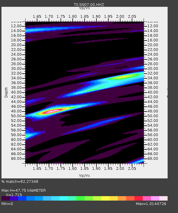
| Estimated Moho Depth: |
47.75 km |
| Estimated Crust Vp/Vs: |
1.72 |
| Assumed Crust Vp: |
6.426 km/s |
| Estimated Crust Vs: |
3.747 km/s |
| Estimated Crust Poisson's Ratio: |
0.24 |
|
| Radial Match: |
92.27349 % |
| Radial Bump: |
324 |
| Transverse Match: |
88.08768 % |
| Transverse Bump: |
400 |
| SOD ConfigId: |
22732711 |
| Insert Time: |
2020-10-15 02:17:19.706 +0000 |
| GWidth: |
2.5 |
| Max Bumps: |
400 |
| Tol: |
0.001 |
|

Signal To Noise
| Channel | StoN | STA | LTA |
| TX:SN07:00:HHZ:20201001T01:25:49.740004Z | 20.89346 | 5.3843532E-6 | 2.577052E-7 |
| TX:SN07:00:HH1:20201001T01:25:49.740004Z | 8.4078 | 8.195514E-7 | 9.747514E-8 |
| TX:SN07:00:HH2:20201001T01:25:49.740004Z | 9.404779 | 1.2887145E-6 | 1.3702763E-7 |
| Arrivals |
| Ps | 5.4 SECOND |
| PpPs | 20 SECOND |
| PsPs/PpSs | 25 SECOND |


