You are here: Home > Network List > TX - Texas Seismological Network Stations List
> Station PB17 Fort Stockton > Earthquake Result Viewer
PB17 Fort Stockton - Earthquake Result Viewer
| Earthquake location: |
Tonga Islands |
| Earthquake latitude/longitude: |
-19.5/-174.2 |
| Earthquake time(UTC): |
2020/10/01 (275) 01:13:37 GMT |
| Earthquake Depth: |
35 km |
| Earthquake Magnitude: |
6.4 Mww |
| Earthquake Catalog/Contributor: |
NEIC PDE/us |
|
| Network: |
TX Texas Seismological Network |
| Station: |
PB17 Fort Stockton |
| Lat/Lon: |
31.00 N/103.15 W |
| Elevation: |
734 m |
|
| Distance: |
84.7 deg |
| Az: |
54.667 deg |
| Baz: |
243.667 deg |
| Ray Param: |
0.045268692 |
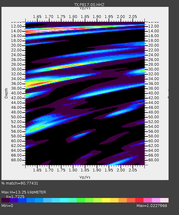
| Estimated Moho Depth: |
13.25 km |
| Estimated Crust Vp/Vs: |
1.72 |
| Assumed Crust Vp: |
6.121 km/s |
| Estimated Crust Vs: |
3.553 km/s |
| Estimated Crust Poisson's Ratio: |
0.25 |
|
| Radial Match: |
90.77431 % |
| Radial Bump: |
400 |
| Transverse Match: |
86.7964 % |
| Transverse Bump: |
400 |
| SOD ConfigId: |
22732711 |
| Insert Time: |
2020-10-15 02:17:30.907 +0000 |
| GWidth: |
2.5 |
| Max Bumps: |
400 |
| Tol: |
0.001 |
|

Signal To Noise
| Channel | StoN | STA | LTA |
| TX:PB17:00:HHZ:20201001T01:25:36.779982Z | 28.526667 | 6.871394E-6 | 2.4087615E-7 |
| TX:PB17:00:HH1:20201001T01:25:36.779982Z | 4.824276 | 7.092461E-7 | 1.4701607E-7 |
| TX:PB17:00:HH2:20201001T01:25:36.779982Z | 5.5010896 | 1.2565965E-6 | 2.2842684E-7 |
| Arrivals |
| Ps | 1.6 SECOND |
| PpPs | 5.8 SECOND |
| PsPs/PpSs | 7.4 SECOND |


