You are here: Home > Network List > PF - Volcanologic Network of Piton de Fournaise-OVPF Stations List
> Station HIM cratere Himiltrude > Earthquake Result Viewer
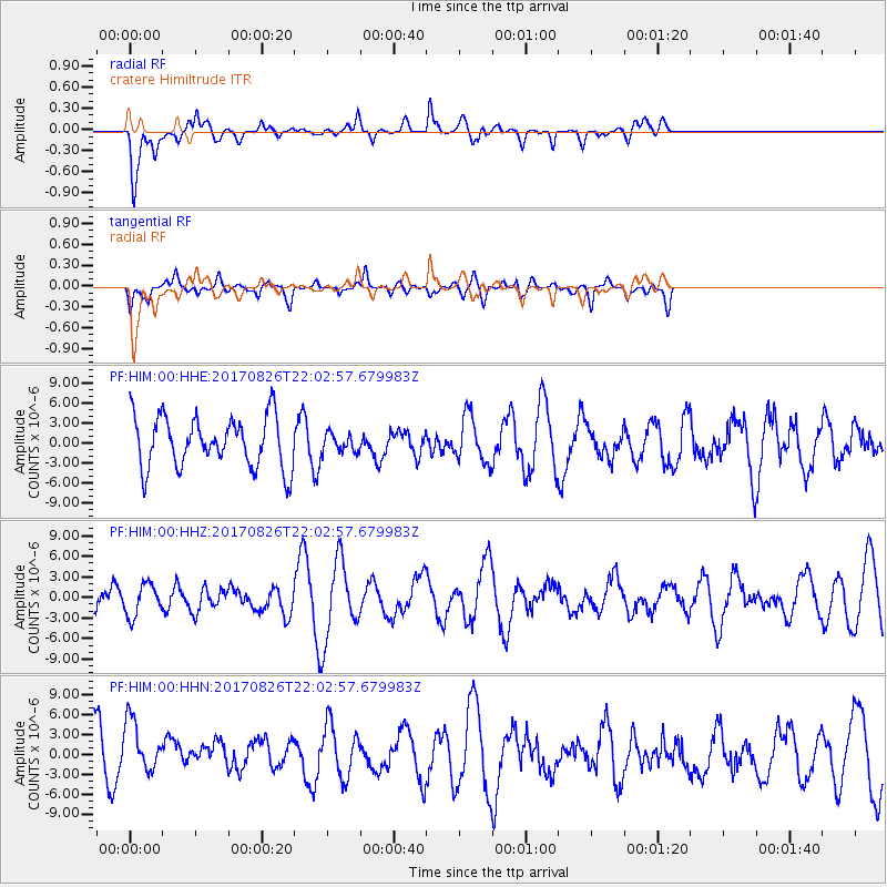
HIM cratere Himiltrude - Earthquake Result Viewer
*The percent match for this event was below the threshold and hence no stack was calculated.
| Earthquake location: |
North Of Macquarie Island |
| Earthquake latitude/longitude: |
-47.3/160.0 |
| Earthquake time(UTC): |
2017/08/26 (238) 21:50:59 GMT |
| Earthquake Depth: |
10 km |
| Earthquake Magnitude: |
5.5 Mww |
| Earthquake Catalog/Contributor: |
NEIC PDE/us |
|
| Network: |
PF Volcanologic Network of Piton de Fournaise-OVPF |
| Station: |
HIM cratere Himiltrude |
| Lat/Lon: |
21.21 S/55.72 E |
| Elevation: |
1958 m |
|
| Distance: |
83.9 deg |
| Az: |
245.405 deg |
| Baz: |
138.419 deg |
| Ray Param: |
$rayparam |
*The percent match for this event was below the threshold and hence was not used in the summary stack. |
|
| Radial Match: |
67.64228 % |
| Radial Bump: |
400 |
| Transverse Match: |
78.73894 % |
| Transverse Bump: |
400 |
| SOD ConfigId: |
2140511 |
| Insert Time: |
2017-09-09 13:49:08.528 +0000 |
| GWidth: |
2.5 |
| Max Bumps: |
400 |
| Tol: |
0.001 |
|
Signal To Noise
| Channel | StoN | STA | LTA |
| PF:HIM:00:HHZ:20170826T22:02:57.679983Z | 0.8077755 | 2.321728E-6 | 2.8742243E-6 |
| PF:HIM:00:HHN:20170826T22:02:57.679983Z | 1.2303693 | 4.243919E-6 | 3.4493053E-6 |
| PF:HIM:00:HHE:20170826T22:02:57.679983Z | 0.36413983 | 1.3977718E-6 | 3.838558E-6 |
| Arrivals |
| Ps | |
| PpPs | |
| PsPs/PpSs | |


