You are here: Home > Network List > US - United States National Seismic Network Stations List
> Station DGMT Dagmar, Montana, USA > Earthquake Result Viewer
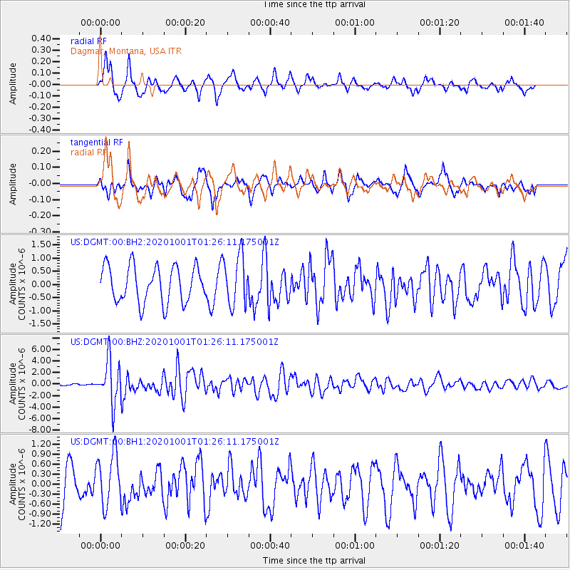
DGMT Dagmar, Montana, USA - Earthquake Result Viewer
*The percent match for this event was below the threshold and hence no stack was calculated.
| Earthquake location: |
Tonga Islands |
| Earthquake latitude/longitude: |
-19.5/-174.2 |
| Earthquake time(UTC): |
2020/10/01 (275) 01:13:37 GMT |
| Earthquake Depth: |
35 km |
| Earthquake Magnitude: |
6.4 Mww |
| Earthquake Catalog/Contributor: |
NEIC PDE/us |
|
| Network: |
US United States National Seismic Network |
| Station: |
DGMT Dagmar, Montana, USA |
| Lat/Lon: |
48.47 N/104.20 W |
| Elevation: |
0.0 m |
|
| Distance: |
91.9 deg |
| Az: |
38.743 deg |
| Baz: |
242.516 deg |
| Ray Param: |
$rayparam |
*The percent match for this event was below the threshold and hence was not used in the summary stack. |
|
| Radial Match: |
57.51822 % |
| Radial Bump: |
325 |
| Transverse Match: |
65.39087 % |
| Transverse Bump: |
400 |
| SOD ConfigId: |
22732711 |
| Insert Time: |
2020-10-15 02:18:38.011 +0000 |
| GWidth: |
2.5 |
| Max Bumps: |
400 |
| Tol: |
0.001 |
|
Signal To Noise
| Channel | StoN | STA | LTA |
| US:DGMT:00:BHZ:20201001T01:26:11.175001Z | 18.155912 | 3.8273292E-6 | 2.1080346E-7 |
| US:DGMT:00:BH1:20201001T01:26:11.175001Z | 1.4457232 | 7.8624953E-7 | 5.4384515E-7 |
| US:DGMT:00:BH2:20201001T01:26:11.175001Z | 1.3789167 | 9.4664466E-7 | 6.8651326E-7 |
| Arrivals |
| Ps | |
| PpPs | |
| PsPs/PpSs | |


