You are here: Home > Network List > UU - University of Utah Regional Network Stations List
> Station HVU Hansel Valley, UT, USA > Earthquake Result Viewer
HVU Hansel Valley, UT, USA - Earthquake Result Viewer
| Earthquake location: |
Tonga Islands |
| Earthquake latitude/longitude: |
-19.5/-174.2 |
| Earthquake time(UTC): |
2020/10/01 (275) 01:13:37 GMT |
| Earthquake Depth: |
35 km |
| Earthquake Magnitude: |
6.4 Mww |
| Earthquake Catalog/Contributor: |
NEIC PDE/us |
|
| Network: |
UU University of Utah Regional Network |
| Station: |
HVU Hansel Valley, UT, USA |
| Lat/Lon: |
41.78 N/112.78 W |
| Elevation: |
1609 m |
|
| Distance: |
83.3 deg |
| Az: |
41.417 deg |
| Baz: |
236.553 deg |
| Ray Param: |
0.046255477 |
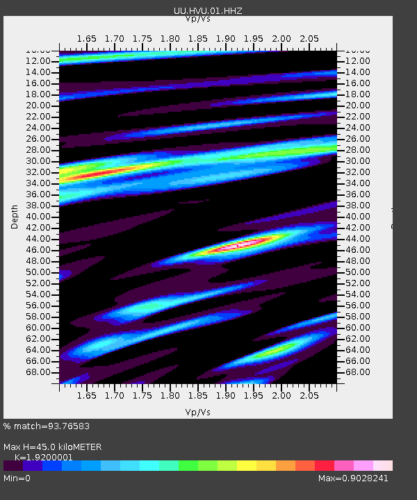
| Estimated Moho Depth: |
45.0 km |
| Estimated Crust Vp/Vs: |
1.92 |
| Assumed Crust Vp: |
6.276 km/s |
| Estimated Crust Vs: |
3.269 km/s |
| Estimated Crust Poisson's Ratio: |
0.31 |
|
| Radial Match: |
93.76583 % |
| Radial Bump: |
282 |
| Transverse Match: |
83.9878 % |
| Transverse Bump: |
377 |
| SOD ConfigId: |
22732711 |
| Insert Time: |
2020-10-15 02:19:44.833 +0000 |
| GWidth: |
2.5 |
| Max Bumps: |
400 |
| Tol: |
0.001 |
|
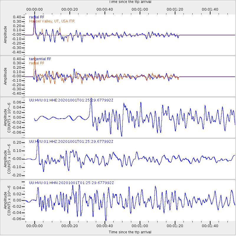
Signal To Noise
| Channel | StoN | STA | LTA |
| UU:HVU:01:HHZ:20201001T01:25:29.677992Z | 20.997217 | 9.298335E-8 | 4.4283657E-9 |
| UU:HVU:01:HHN:20201001T01:25:29.677992Z | 3.773071 | 1.7879279E-8 | 4.738654E-9 |
| UU:HVU:01:HHE:20201001T01:25:29.677992Z | 6.100795 | 3.0971403E-8 | 5.076618E-9 |
| Arrivals |
| Ps | 6.7 SECOND |
| PpPs | 20 SECOND |
| PsPs/PpSs | 27 SECOND |


