You are here: Home > Network List > UU - University of Utah Regional Network Stations List
> Station LIUT Lila Canyon, UT, USA > Earthquake Result Viewer
LIUT Lila Canyon, UT, USA - Earthquake Result Viewer
| Earthquake location: |
Tonga Islands |
| Earthquake latitude/longitude: |
-19.5/-174.2 |
| Earthquake time(UTC): |
2020/10/01 (275) 01:13:37 GMT |
| Earthquake Depth: |
35 km |
| Earthquake Magnitude: |
6.4 Mww |
| Earthquake Catalog/Contributor: |
NEIC PDE/us |
|
| Network: |
UU University of Utah Regional Network |
| Station: |
LIUT Lila Canyon, UT, USA |
| Lat/Lon: |
39.42 N/110.33 W |
| Elevation: |
2178 m |
|
| Distance: |
83.6 deg |
| Az: |
44.423 deg |
| Baz: |
238.485 deg |
| Ray Param: |
0.04603481 |
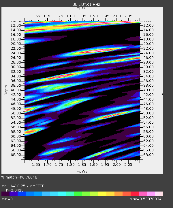
| Estimated Moho Depth: |
10.25 km |
| Estimated Crust Vp/Vs: |
2.04 |
| Assumed Crust Vp: |
6.207 km/s |
| Estimated Crust Vs: |
3.039 km/s |
| Estimated Crust Poisson's Ratio: |
0.34 |
|
| Radial Match: |
90.76046 % |
| Radial Bump: |
400 |
| Transverse Match: |
88.37805 % |
| Transverse Bump: |
385 |
| SOD ConfigId: |
22732711 |
| Insert Time: |
2020-10-15 02:19:48.879 +0000 |
| GWidth: |
2.5 |
| Max Bumps: |
400 |
| Tol: |
0.001 |
|

Signal To Noise
| Channel | StoN | STA | LTA |
| UU:LIUT:01:HHZ:20201001T01:25:31.269972Z | 25.769154 | 1.6433391E-7 | 6.3771557E-9 |
| UU:LIUT:01:HHN:20201001T01:25:31.269972Z | 8.784334 | 3.539246E-8 | 4.029043E-9 |
| UU:LIUT:01:HHE:20201001T01:25:31.269972Z | 4.442227 | 2.7398736E-8 | 6.167793E-9 |
| Arrivals |
| Ps | 1.8 SECOND |
| PpPs | 4.9 SECOND |
| PsPs/PpSs | 6.7 SECOND |


