You are here: Home > Network List > UU - University of Utah Regional Network Stations List
> Station NLU North Lily, UT, USA > Earthquake Result Viewer
NLU North Lily, UT, USA - Earthquake Result Viewer
| Earthquake location: |
Tonga Islands |
| Earthquake latitude/longitude: |
-19.5/-174.2 |
| Earthquake time(UTC): |
2020/10/01 (275) 01:13:37 GMT |
| Earthquake Depth: |
35 km |
| Earthquake Magnitude: |
6.4 Mww |
| Earthquake Catalog/Contributor: |
NEIC PDE/us |
|
| Network: |
UU University of Utah Regional Network |
| Station: |
NLU North Lily, UT, USA |
| Lat/Lon: |
39.95 N/112.07 W |
| Elevation: |
2036 m |
|
| Distance: |
82.7 deg |
| Az: |
43.247 deg |
| Baz: |
237.232 deg |
| Ray Param: |
0.046642754 |
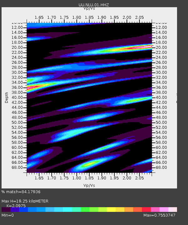
| Estimated Moho Depth: |
19.25 km |
| Estimated Crust Vp/Vs: |
2.10 |
| Assumed Crust Vp: |
6.276 km/s |
| Estimated Crust Vs: |
2.992 km/s |
| Estimated Crust Poisson's Ratio: |
0.35 |
|
| Radial Match: |
84.17936 % |
| Radial Bump: |
400 |
| Transverse Match: |
83.57134 % |
| Transverse Bump: |
338 |
| SOD ConfigId: |
22732711 |
| Insert Time: |
2020-10-15 02:19:52.002 +0000 |
| GWidth: |
2.5 |
| Max Bumps: |
400 |
| Tol: |
0.001 |
|

Signal To Noise
| Channel | StoN | STA | LTA |
| UU:NLU:01:HHZ:20201001T01:25:26.844984Z | 29.158033 | 8.1416715E-8 | 2.7922569E-9 |
| UU:NLU:01:HHN:20201001T01:25:26.844984Z | 3.2237782 | 1.1325862E-8 | 3.5132262E-9 |
| UU:NLU:01:HHE:20201001T01:25:26.844984Z | 8.171561 | 2.898731E-8 | 3.5473404E-9 |
| Arrivals |
| Ps | 3.4 SECOND |
| PpPs | 9.3 SECOND |
| PsPs/PpSs | 13 SECOND |


