You are here: Home > Network List > UW - Pacific Northwest Regional Seismic Network Stations List
> Station BRO Big Rock Lookout, OR, USA > Earthquake Result Viewer
BRO Big Rock Lookout, OR, USA - Earthquake Result Viewer
| Earthquake location: |
Tonga Islands |
| Earthquake latitude/longitude: |
-19.5/-174.2 |
| Earthquake time(UTC): |
2020/10/01 (275) 01:13:37 GMT |
| Earthquake Depth: |
35 km |
| Earthquake Magnitude: |
6.4 Mww |
| Earthquake Catalog/Contributor: |
NEIC PDE/us |
|
| Network: |
UW Pacific Northwest Regional Seismic Network |
| Station: |
BRO Big Rock Lookout, OR, USA |
| Lat/Lon: |
44.27 N/122.45 W |
| Elevation: |
1361 m |
|
| Distance: |
79.1 deg |
| Az: |
35.078 deg |
| Baz: |
228.993 deg |
| Ray Param: |
0.049129296 |
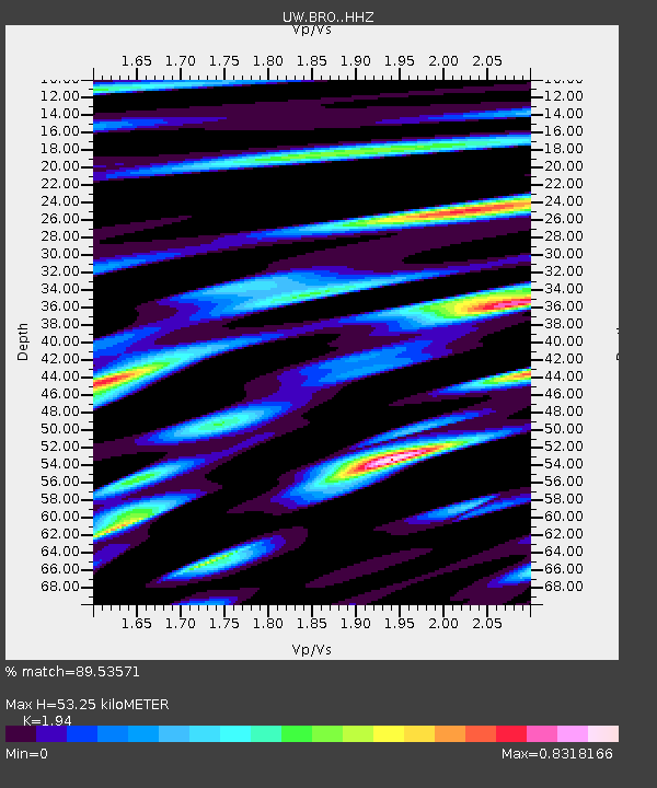
| Estimated Moho Depth: |
53.25 km |
| Estimated Crust Vp/Vs: |
1.94 |
| Assumed Crust Vp: |
6.566 km/s |
| Estimated Crust Vs: |
3.385 km/s |
| Estimated Crust Poisson's Ratio: |
0.32 |
|
| Radial Match: |
89.53571 % |
| Radial Bump: |
400 |
| Transverse Match: |
79.428795 % |
| Transverse Bump: |
400 |
| SOD ConfigId: |
22732711 |
| Insert Time: |
2020-10-15 02:20:20.451 +0000 |
| GWidth: |
2.5 |
| Max Bumps: |
400 |
| Tol: |
0.001 |
|

Signal To Noise
| Channel | StoN | STA | LTA |
| UW:BRO: :HHZ:20201001T01:25:07.719984Z | 13.221952 | 4.1897965E-6 | 3.1688182E-7 |
| UW:BRO: :HHN:20201001T01:25:07.719984Z | 4.548541 | 1.1066877E-6 | 2.433061E-7 |
| UW:BRO: :HHE:20201001T01:25:07.719984Z | 4.220398 | 1.1853996E-6 | 2.8087388E-7 |
| Arrivals |
| Ps | 7.8 SECOND |
| PpPs | 23 SECOND |
| PsPs/PpSs | 31 SECOND |


