You are here: Home > Network List > UW - Pacific Northwest Regional Seismic Network Stations List
> Station FISH Seaside, OR, USA > Earthquake Result Viewer
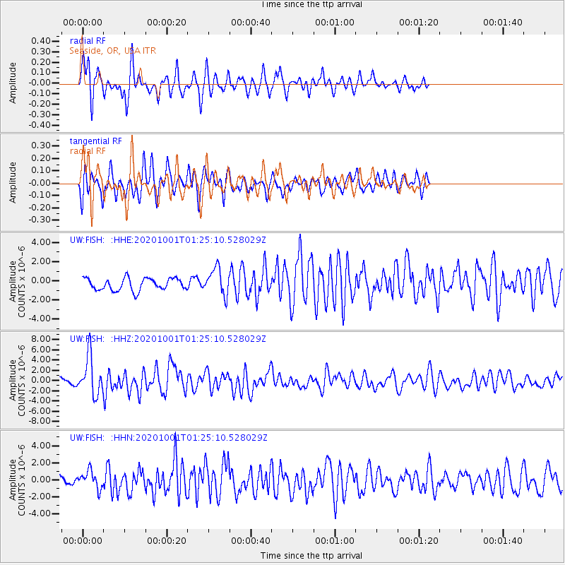
FISH Seaside, OR, USA - Earthquake Result Viewer
*The percent match for this event was below the threshold and hence no stack was calculated.
| Earthquake location: |
Tonga Islands |
| Earthquake latitude/longitude: |
-19.5/-174.2 |
| Earthquake time(UTC): |
2020/10/01 (275) 01:13:37 GMT |
| Earthquake Depth: |
35 km |
| Earthquake Magnitude: |
6.4 Mww |
| Earthquake Catalog/Contributor: |
NEIC PDE/us |
|
| Network: |
UW Pacific Northwest Regional Seismic Network |
| Station: |
FISH Seaside, OR, USA |
| Lat/Lon: |
45.93 N/123.56 W |
| Elevation: |
325 m |
|
| Distance: |
79.6 deg |
| Az: |
33.283 deg |
| Baz: |
227.881 deg |
| Ray Param: |
$rayparam |
*The percent match for this event was below the threshold and hence was not used in the summary stack. |
|
| Radial Match: |
77.70862 % |
| Radial Bump: |
353 |
| Transverse Match: |
72.65163 % |
| Transverse Bump: |
400 |
| SOD ConfigId: |
22732711 |
| Insert Time: |
2020-10-15 02:20:33.413 +0000 |
| GWidth: |
2.5 |
| Max Bumps: |
400 |
| Tol: |
0.001 |
|
Signal To Noise
| Channel | StoN | STA | LTA |
| UW:FISH: :HHZ:20201001T01:25:10.528029Z | 11.69883 | 3.860659E-6 | 3.300039E-7 |
| UW:FISH: :HHN:20201001T01:25:10.528029Z | 1.9575498 | 1.0686774E-6 | 5.4592607E-7 |
| UW:FISH: :HHE:20201001T01:25:10.528029Z | 2.2878895 | 1.4369954E-6 | 6.280878E-7 |
| Arrivals |
| Ps | |
| PpPs | |
| PsPs/PpSs | |


