You are here: Home > Network List > UW - Pacific Northwest Regional Seismic Network Stations List
> Station LEBA Lebam, WA, USA > Earthquake Result Viewer
LEBA Lebam, WA, USA - Earthquake Result Viewer
| Earthquake location: |
Tonga Islands |
| Earthquake latitude/longitude: |
-19.5/-174.2 |
| Earthquake time(UTC): |
2020/10/01 (275) 01:13:37 GMT |
| Earthquake Depth: |
35 km |
| Earthquake Magnitude: |
6.4 Mww |
| Earthquake Catalog/Contributor: |
NEIC PDE/us |
|
| Network: |
UW Pacific Northwest Regional Seismic Network |
| Station: |
LEBA Lebam, WA, USA |
| Lat/Lon: |
46.55 N/123.56 W |
| Elevation: |
73 m |
|
| Distance: |
80.1 deg |
| Az: |
32.817 deg |
| Baz: |
227.796 deg |
| Ray Param: |
0.048495594 |
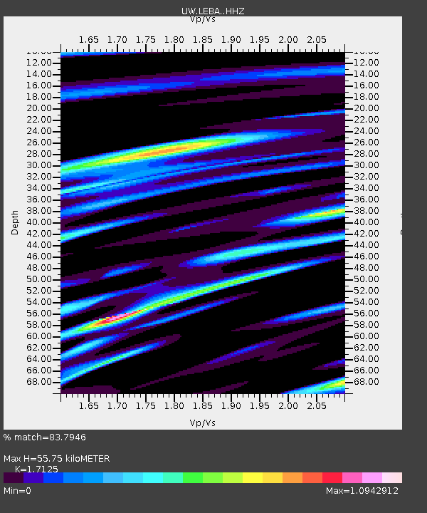
| Estimated Moho Depth: |
55.75 km |
| Estimated Crust Vp/Vs: |
1.71 |
| Assumed Crust Vp: |
6.566 km/s |
| Estimated Crust Vs: |
3.834 km/s |
| Estimated Crust Poisson's Ratio: |
0.24 |
|
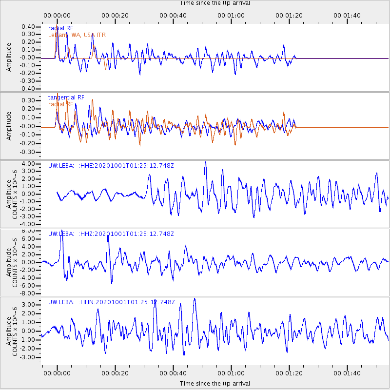
| Radial Match: |
83.7946 % |
| Radial Bump: |
400 |
| Transverse Match: |
71.24018 % |
| Transverse Bump: |
400 |
| SOD ConfigId: |
22732711 |
| Insert Time: |
2020-10-15 02:20:51.312 +0000 |
| GWidth: |
2.5 |
| Max Bumps: |
400 |
| Tol: |
0.001 |
|
Signal To Noise
| Channel | StoN | STA | LTA |
| UW:LEBA: :HHZ:20201001T01:25:12.748Z | 16.446344 | 3.5679147E-6 | 2.1694272E-7 |
| UW:LEBA: :HHN:20201001T01:25:12.748Z | 1.5728824 | 4.952588E-7 | 3.1487338E-7 |
| UW:LEBA: :HHE:20201001T01:25:12.748Z | 2.8638315 | 1.1234108E-6 | 3.9227544E-7 |
| Arrivals |
| Ps | 6.2 SECOND |
| PpPs | 22 SECOND |
| PsPs/PpSs | 29 SECOND |


