You are here: Home > Network List > XT97 - Colorado BB Array - Lodore Stations List
> Station LANG XT.LANG > Earthquake Result Viewer
LANG XT.LANG - Earthquake Result Viewer
| Earthquake location: |
Southern Alaska |
| Earthquake latitude/longitude: |
60.5/-153.2 |
| Earthquake time(UTC): |
1998/07/09 (190) 19:39:43 GMT |
| Earthquake Depth: |
145 km |
| Earthquake Magnitude: |
5.3 MB, 6.2 UNKNOWN, 6.2 MW |
| Earthquake Catalog/Contributor: |
WHDF/NEIC |
|
| Network: |
XT Colorado BB Array - Lodore |
| Station: |
LANG XT.LANG |
| Lat/Lon: |
40.87 N/108.29 W |
| Elevation: |
2258 m |
|
| Distance: |
33.7 deg |
| Az: |
105.083 deg |
| Baz: |
320.98 deg |
| Ray Param: |
0.07763943 |
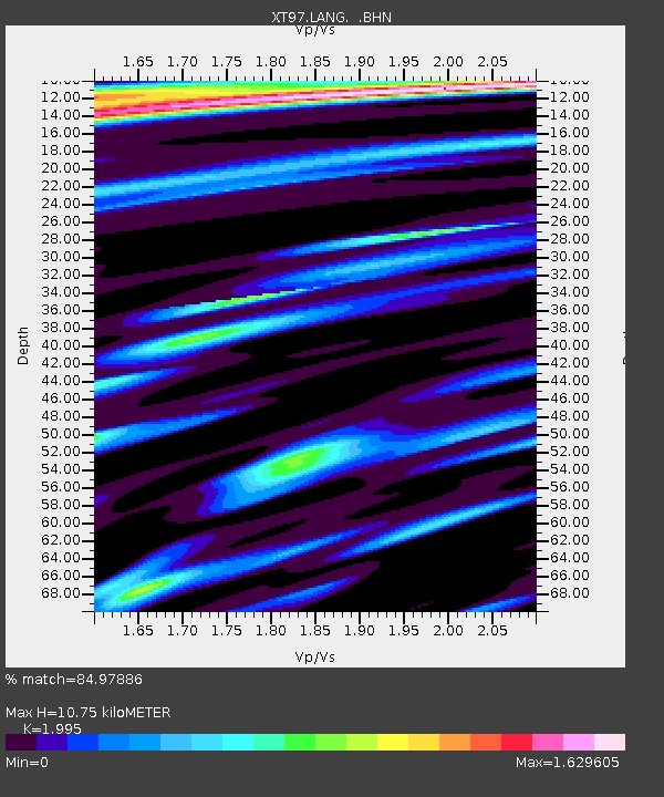
| Estimated Moho Depth: |
10.75 km |
| Estimated Crust Vp/Vs: |
2.00 |
| Assumed Crust Vp: |
6.207 km/s |
| Estimated Crust Vs: |
3.111 km/s |
| Estimated Crust Poisson's Ratio: |
0.33 |
|
| Radial Match: |
84.97886 % |
| Radial Bump: |
400 |
| Transverse Match: |
76.50031 % |
| Transverse Bump: |
400 |
| SOD ConfigId: |
4480 |
| Insert Time: |
2010-03-09 01:37:21.700 +0000 |
| GWidth: |
2.5 |
| Max Bumps: |
400 |
| Tol: |
0.001 |
|

Signal To Noise
| Channel | StoN | STA | LTA |
| XT:LANG: :BHN:19980709T19:45:40.798987Z | 5.398942 | 3.729896E-7 | 6.908568E-8 |
| XT:LANG: :BHE:19980709T19:45:40.798987Z | 1.8176539 | 1.3672377E-7 | 7.521991E-8 |
| XT:LANG: :BHZ:19980709T19:45:40.798987Z | 0.8697693 | 1.0687104E-7 | 1.2287286E-7 |
| Arrivals |
| Ps | 1.8 SECOND |
| PpPs | 4.9 SECOND |
| PsPs/PpSs | 6.7 SECOND |


