You are here: Home > Network List > UW - Pacific Northwest Regional Seismic Network Stations List
> Station WA2 Wahluke Slope previous ISC code: WAH2 > Earthquake Result Viewer
WA2 Wahluke Slope previous ISC code: WAH2 - Earthquake Result Viewer
| Earthquake location: |
Tonga Islands |
| Earthquake latitude/longitude: |
-19.5/-174.2 |
| Earthquake time(UTC): |
2020/10/01 (275) 01:13:37 GMT |
| Earthquake Depth: |
35 km |
| Earthquake Magnitude: |
6.4 Mww |
| Earthquake Catalog/Contributor: |
NEIC PDE/us |
|
| Network: |
UW Pacific Northwest Regional Seismic Network |
| Station: |
WA2 Wahluke Slope previous ISC code: WAH2 |
| Lat/Lon: |
46.76 N/119.57 W |
| Elevation: |
244 m |
|
| Distance: |
82.3 deg |
| Az: |
34.47 deg |
| Baz: |
230.947 deg |
| Ray Param: |
0.04695079 |
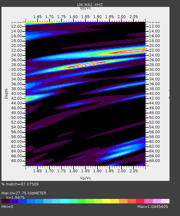
| Estimated Moho Depth: |
27.75 km |
| Estimated Crust Vp/Vs: |
1.85 |
| Assumed Crust Vp: |
6.419 km/s |
| Estimated Crust Vs: |
3.475 km/s |
| Estimated Crust Poisson's Ratio: |
0.29 |
|
| Radial Match: |
87.07509 % |
| Radial Bump: |
400 |
| Transverse Match: |
79.57163 % |
| Transverse Bump: |
400 |
| SOD ConfigId: |
22732711 |
| Insert Time: |
2020-10-15 02:21:30.832 +0000 |
| GWidth: |
2.5 |
| Max Bumps: |
400 |
| Tol: |
0.001 |
|

Signal To Noise
| Channel | StoN | STA | LTA |
| UW:WA2: :HHZ:20201001T01:25:24.519972Z | 15.4576435 | 3.4715747E-6 | 2.2458627E-7 |
| UW:WA2: :HHN:20201001T01:25:24.519972Z | 6.6787415 | 9.62321E-7 | 1.4408718E-7 |
| UW:WA2: :HHE:20201001T01:25:24.519972Z | 4.286072 | 6.812271E-7 | 1.5893974E-7 |
| Arrivals |
| Ps | 3.8 SECOND |
| PpPs | 12 SECOND |
| PsPs/PpSs | 16 SECOND |


