You are here: Home > Network List > UW - Pacific Northwest Regional Seismic Network Stations List
> Station HILL La Conner, WA, USA > Earthquake Result Viewer
HILL La Conner, WA, USA - Earthquake Result Viewer
| Earthquake location: |
Tonga Islands |
| Earthquake latitude/longitude: |
-19.5/-174.2 |
| Earthquake time(UTC): |
2020/10/01 (275) 01:13:37 GMT |
| Earthquake Depth: |
35 km |
| Earthquake Magnitude: |
6.4 Mww |
| Earthquake Catalog/Contributor: |
NEIC PDE/us |
|
| Network: |
UW Pacific Northwest Regional Seismic Network |
| Station: |
HILL La Conner, WA, USA |
| Lat/Lon: |
48.39 N/122.45 W |
| Elevation: |
38 m |
|
| Distance: |
81.8 deg |
| Az: |
31.939 deg |
| Baz: |
228.478 deg |
| Ray Param: |
0.047250994 |
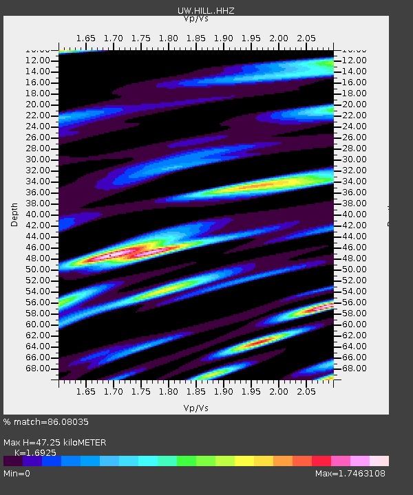
| Estimated Moho Depth: |
47.25 km |
| Estimated Crust Vp/Vs: |
1.69 |
| Assumed Crust Vp: |
6.566 km/s |
| Estimated Crust Vs: |
3.88 km/s |
| Estimated Crust Poisson's Ratio: |
0.23 |
|
| Radial Match: |
86.08035 % |
| Radial Bump: |
400 |
| Transverse Match: |
82.95913 % |
| Transverse Bump: |
400 |
| SOD ConfigId: |
22732711 |
| Insert Time: |
2020-10-15 02:21:43.935 +0000 |
| GWidth: |
2.5 |
| Max Bumps: |
400 |
| Tol: |
0.001 |
|

Signal To Noise
| Channel | StoN | STA | LTA |
| UW:HILL: :HHZ:20201001T01:25:22.269972Z | 15.560155 | 3.3921801E-6 | 2.1800427E-7 |
| UW:HILL: :HHN:20201001T01:25:22.269972Z | 9.938717 | 1.9239706E-6 | 1.935834E-7 |
| UW:HILL: :HHE:20201001T01:25:22.269972Z | 5.332391 | 1.3439005E-6 | 2.520259E-7 |
| Arrivals |
| Ps | 5.1 SECOND |
| PpPs | 19 SECOND |
| PsPs/PpSs | 24 SECOND |


