You are here: Home > Network List > WY - Yellowstone Wyoming Seismic Network Stations List
> Station YTP The Promontory, YNP, WY, USA > Earthquake Result Viewer
YTP The Promontory, YNP, WY, USA - Earthquake Result Viewer
| Earthquake location: |
Tonga Islands |
| Earthquake latitude/longitude: |
-19.5/-174.2 |
| Earthquake time(UTC): |
2020/10/01 (275) 01:13:37 GMT |
| Earthquake Depth: |
35 km |
| Earthquake Magnitude: |
6.4 Mww |
| Earthquake Catalog/Contributor: |
NEIC PDE/us |
|
| Network: |
WY Yellowstone Wyoming Seismic Network |
| Station: |
YTP The Promontory, YNP, WY, USA |
| Lat/Lon: |
44.39 N/110.29 W |
| Elevation: |
2384 m |
|
| Distance: |
86.2 deg |
| Az: |
40.198 deg |
| Baz: |
238.137 deg |
| Ray Param: |
0.044160742 |
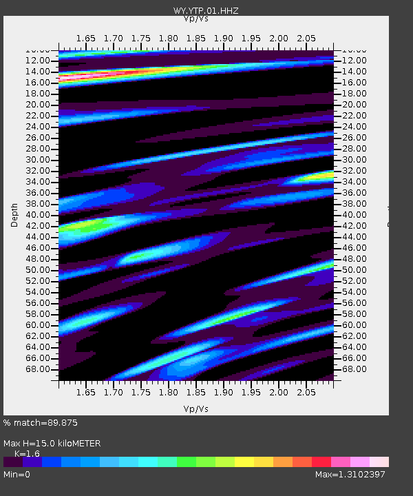
| Estimated Moho Depth: |
15.0 km |
| Estimated Crust Vp/Vs: |
1.60 |
| Assumed Crust Vp: |
6.35 km/s |
| Estimated Crust Vs: |
3.969 km/s |
| Estimated Crust Poisson's Ratio: |
0.18 |
|
| Radial Match: |
89.875 % |
| Radial Bump: |
355 |
| Transverse Match: |
90.46978 % |
| Transverse Bump: |
391 |
| SOD ConfigId: |
22732711 |
| Insert Time: |
2020-10-15 02:22:04.125 +0000 |
| GWidth: |
2.5 |
| Max Bumps: |
400 |
| Tol: |
0.001 |
|

Signal To Noise
| Channel | StoN | STA | LTA |
| WY:YTP:01:HHZ:20201001T01:25:44.448012Z | 18.286161 | 7.676885E-8 | 4.198194E-9 |
| WY:YTP:01:HHN:20201001T01:25:44.448012Z | 6.1329165 | 1.7663666E-8 | 2.8801412E-9 |
| WY:YTP:01:HHE:20201001T01:25:44.448012Z | 4.632561 | 1.8589825E-8 | 4.012861E-9 |
| Arrivals |
| Ps | 1.5 SECOND |
| PpPs | 6.0 SECOND |
| PsPs/PpSs | 7.4 SECOND |


