You are here: Home > Network List > GS - US Geological Survey Networks Stations List
> Station MT01 Lincoln Ranger Stn, Helena Natl Forest, Montana, USA > Earthquake Result Viewer
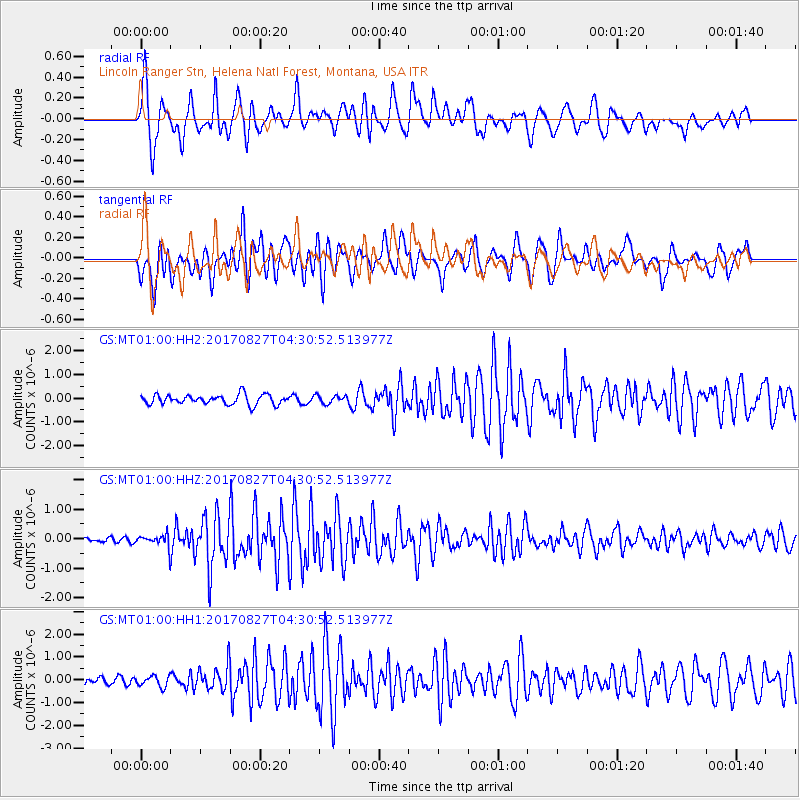
MT01 Lincoln Ranger Stn, Helena Natl Forest, Montana, USA - Earthquake Result Viewer
*The percent match for this event was below the threshold and hence no stack was calculated.
| Earthquake location: |
Admiralty Islands Region, P.N.G. |
| Earthquake latitude/longitude: |
-1.4/148.1 |
| Earthquake time(UTC): |
2017/08/27 (239) 04:17:51 GMT |
| Earthquake Depth: |
10 km |
| Earthquake Magnitude: |
6.6 Mi |
| Earthquake Catalog/Contributor: |
NEIC PDE/at |
|
| Network: |
GS US Geological Survey Networks |
| Station: |
MT01 Lincoln Ranger Stn, Helena Natl Forest, Montana, USA |
| Lat/Lon: |
46.95 N/112.66 W |
| Elevation: |
1318 m |
|
| Distance: |
97.3 deg |
| Az: |
42.979 deg |
| Baz: |
275.808 deg |
| Ray Param: |
$rayparam |
*The percent match for this event was below the threshold and hence was not used in the summary stack. |
|
| Radial Match: |
78.77937 % |
| Radial Bump: |
400 |
| Transverse Match: |
63.956924 % |
| Transverse Bump: |
400 |
| SOD ConfigId: |
2140511 |
| Insert Time: |
2017-09-09 20:12:00.939 +0000 |
| GWidth: |
2.5 |
| Max Bumps: |
400 |
| Tol: |
0.001 |
|
Signal To Noise
| Channel | StoN | STA | LTA |
| GS:MT01:00:HHZ:20170827T04:30:52.513977Z | 2.9935033 | 2.0903519E-7 | 6.982962E-8 |
| GS:MT01:00:HH1:20170827T04:30:52.513977Z | 1.0026985 | 2.3690903E-7 | 2.3627143E-7 |
| GS:MT01:00:HH2:20170827T04:30:52.513977Z | 0.81757 | 1.6943805E-7 | 2.0724593E-7 |
| Arrivals |
| Ps | |
| PpPs | |
| PsPs/PpSs | |


